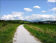
Two years ago we rode the northern half of the Ammonoosuc Rail Trail from Littleton to Lisbon and had a great ride on a wonderful rail trail. With a little prompting from the usual suspects (you know who you are) and a forecast for a beautiful day it seems that tomorrow would be the perfect day to complete our exploration on the southern section of this trail. The Ammonoosuc River provides a gorgeous backdrop to this trail. And there is a magnificent 345 foot covered bridge that was built in 1832 in Bath.
The Ammonoosuc Rail Trail from Woodsville to Lisbon wends its way along the Ammonoosuc River by field, farm, quaint villages and some very interesting backyards. In all we’ll cover about 20 miles on this easy and flat dirt track. After getting to Lisbon we’ll turn around and head back to our lunch spot in Bath which is a quintessentially scenic New England Village with a gorgeous covered bridge and a well stocked General Store. And the last time I was in Bath there was an ice cream store and an art gallery too. What’s a better combination than culture and ice cream?
Directions and Carpooling: Meet at 8:30 in the back of the Attitash parking lot. There are several ways to get to Woodsville that take about the same amount of time. There’s (A) 302 to 93 to 302 or (B) Bear Notch road to 112 to 302 or (C) 302 to 93 to 117 to 302. So pick your favorite and meet us at about 10am at the starting point in Woodsville.
When you approach Woodsville there is a stop light at the intersection of routes 302 and 10. Go west toward downtown Woodsville on 302 for about ¾ of a mile. After awhile you will probably see a dirt path paralleling 302 on the right. This is the rail trail. At Highland St go right and then take a quick left on a dirt road/driveway. We will park in the dirt lot just down from the Railway Farm and Garden Store and Central Supply.
Go here for a trail map:
http://www.mapmyride.com/routes/view/11620932
For those who want a little extra riding (6 mi.) you can explore the Blackmount spur to North Haverill from Woodsville at the end of our ride
Monday, June 27, 2011

Sunday, June 19, 2011
Pondicherry - The Lupine Tour
The weather forecast looks great for Tuesday June 21st! Let's do an amazingly scenic ride in the Jefferson area while the lupine are blooming.
We’ll start at the western terminus of The Presidential Range Rail Trail and pedal through almost four miles of The Pondicherry National Wildlife Refuge where the views are absolutely magnificent. Then we’ll head for more open vistas on three miles of paved country road and another three plus miles on the dirt Valley Road. When we reach Jefferson Notch Road we will return to Pondicherry on The Rail Trail. In all we’ll cover about 18 miles with breath taking spring views and lots of gorgeous lupine.
The rail trail has a pretty firm surface and is a combination of dirt, gravel, stone, cinder and ballast. Since the new culverts and bridges were installed more than a year ago, the rail trail has been solid and dry. This is a relatively flat route with no major hills. It’s just a wonderful cruise through a beautiful area.
Bring your cameras; the scenery here creates magazine quality photos!!!
Directions: Take route 302 through Bretton Woods and at the traffic light go right on route 3 for 1.9 miles. Then take another right on route 115. In 4.4 miles Hazen Road will be on your left, take it. In another 1.4 miles you will see a sign on the right saying Presidential Recreation Trail Pondicherry. Go right into the small parking lot. We may have to do some creative parking to fit us all in here.
Carpooling is a must due to the small parking lot at Pondicherry. Meet at 8:55am in the Attitash parking lot. Please be ready to ride at 10:00am.
Click here for a map of this ride.
http://www.mapmyride.com/routes/view/11313897
We’ll start at the western terminus of The Presidential Range Rail Trail and pedal through almost four miles of The Pondicherry National Wildlife Refuge where the views are absolutely magnificent. Then we’ll head for more open vistas on three miles of paved country road and another three plus miles on the dirt Valley Road. When we reach Jefferson Notch Road we will return to Pondicherry on The Rail Trail. In all we’ll cover about 18 miles with breath taking spring views and lots of gorgeous lupine.
The rail trail has a pretty firm surface and is a combination of dirt, gravel, stone, cinder and ballast. Since the new culverts and bridges were installed more than a year ago, the rail trail has been solid and dry. This is a relatively flat route with no major hills. It’s just a wonderful cruise through a beautiful area.
Bring your cameras; the scenery here creates magazine quality photos!!!
Directions: Take route 302 through Bretton Woods and at the traffic light go right on route 3 for 1.9 miles. Then take another right on route 115. In 4.4 miles Hazen Road will be on your left, take it. In another 1.4 miles you will see a sign on the right saying Presidential Recreation Trail Pondicherry. Go right into the small parking lot. We may have to do some creative parking to fit us all in here.
Carpooling is a must due to the small parking lot at Pondicherry. Meet at 8:55am in the Attitash parking lot. Please be ready to ride at 10:00am.
Click here for a map of this ride.
http://www.mapmyride.com/routes/view/11313897
Sunday, June 12, 2011
June 14, 2011
Update - It's lightening up, let's ride!
Another forecast with a possibility (40%) of rain, ergh. Well let's think positively and plan for a ride tomorrow. How about another close to home ride in case we need to bail out (literally) early?
So let's explore the trails around and near Thorne Pond and the Saco in Bartlett. These fun and virtually flat trails range from logging type roads to single track. While most of the trails are appropriate for an experienced novice, there will, occasionally, be quick turns, roots, stones and mud to ride around or over. There are a couple of spots where getting off the bike may be advisable. There aren't any difficult trails. So we should have a very nice ride. And if it does start to rain we won’t be very far from our cars.
We'll meet in the back of the Attitash parking lot, across route 302 from the mountain. Park in the back of the lot by the parking shack to avoid using spaces that Attitash customers might need. Be ready to ride at 10:00am.
Rain in the morning will cancel the ride. Check back here tomorrow morning around 8:00am to confirm that the ride is still on.
Another forecast with a possibility (40%) of rain, ergh. Well let's think positively and plan for a ride tomorrow. How about another close to home ride in case we need to bail out (literally) early?
So let's explore the trails around and near Thorne Pond and the Saco in Bartlett. These fun and virtually flat trails range from logging type roads to single track. While most of the trails are appropriate for an experienced novice, there will, occasionally, be quick turns, roots, stones and mud to ride around or over. There are a couple of spots where getting off the bike may be advisable. There aren't any difficult trails. So we should have a very nice ride. And if it does start to rain we won’t be very far from our cars.
We'll meet in the back of the Attitash parking lot, across route 302 from the mountain. Park in the back of the lot by the parking shack to avoid using spaces that Attitash customers might need. Be ready to ride at 10:00am.
Rain in the morning will cancel the ride. Check back here tomorrow morning around 8:00am to confirm that the ride is still on.
Monday, June 6, 2011
Echo Lake and Cedar Creek Trails
Tomorrow, Tuesday June 7th, let's plan on riding the trails near Echo Lake and the National Forest trails to the west of the Cedar Creek and Birch Hill neighborhoods off West Side Road in North Conway.
Most of the ride is pretty flat and suitable for all abilities. So for those of you who are fairly new to fat tire riding this would be a great ride. We will cover about 4 miles of pavement and 8-10 miles of dirt forest trails. We will cross a couple of brooks, and most of us should keep our feet dry.
We'll meet at 10:00am in the parking lot just outside and to the left of the gates to Echo Lake State Park in North Conway. From there we'll ride south on West Side Road for about 3 miles and then enter The National Forest on a trail in the Cedar Creek Development. After exploring the forest roads and an old rail bed in the Moat Trail system we'll head north back to the trails by Echo Lake for further explorations.
Bug spray is recommended. And bring your lunch. See you there.
Most of the ride is pretty flat and suitable for all abilities. So for those of you who are fairly new to fat tire riding this would be a great ride. We will cover about 4 miles of pavement and 8-10 miles of dirt forest trails. We will cross a couple of brooks, and most of us should keep our feet dry.
We'll meet at 10:00am in the parking lot just outside and to the left of the gates to Echo Lake State Park in North Conway. From there we'll ride south on West Side Road for about 3 miles and then enter The National Forest on a trail in the Cedar Creek Development. After exploring the forest roads and an old rail bed in the Moat Trail system we'll head north back to the trails by Echo Lake for further explorations.
Bug spray is recommended. And bring your lunch. See you there.
Sunday, May 29, 2011
May 31, 2011 Ride
Tuesday's forecast looks fine and it's about time. So how about a fairly easy, well drained and gorgeous route! This will be one of the most beautiful rides of the season!!! There's lots of water and lots of fabulous views. This is a special ride. And we can stop at the Northland Dairy for a yummy after ride treat.
The ride starts across the street from the Berlin Airport. We'll go north on the rural and quiet East Side River Road which closely follows the Androscoggin River and has wonderful views. Next we'll turn right onto Hill Street, a dirt road which gently rises through woods and farm lands and takes us on a loop and back to East Side River Road. From here we'll ride to dirt roads which parallel a hydropower canal before getting us to the seldom visited east side of the Androscoggin River. Before starting our return on East Side River Road we'll stop by the hydro station south of the dam where there is a lovely water front spot for lunch.
To see the map of this 18 mile ride click here: http://www.mapmyride.com/routes/view/17313468
Take route 16 north through Berlin. About 3 miles past the Nansen Wayside Park (old ski jump on the left and waterfront park on right), Bridge Street will be on the right. You should also see an airport sign pointing right too. Cross over the Androscoggin River and at the end of Bridge Street pull into the ball park lot on your left
Carpool: Meet at 9:0oam at The Old Jackson Town Hall which is across the street from the Post Office.
Please be ready to ride at 10:00am Tuesday May 25th. See you there for a very special ride.
To see the map of this 18 mile ride click here: http://www.mapmyride.com/routes/view/17313468
Take route 16 north through Berlin. About 3 miles past the Nansen Wayside Park (old ski jump on the left and waterfront park on right), Bridge Street will be on the right. You should also see an airport sign pointing right too. Cross over the Androscoggin River and at the end of Bridge Street pull into the ball park lot on your left
Carpool: Meet at 9:0oam at The Old Jackson Town Hall which is across the street from the Post Office.
Please be ready to ride at 10:00am Tuesday May 25th. See you there for a very special ride.
Monday, May 23, 2011
Fryeburg Black and Tan
Tuesday Morning Update:
It looks like we'll have a window of bike ride opportunity. Let's Go!
There is a sun up there. I almost saw it yesterday! So let's be positive and plan for a ride tomorrow. We need a route that is well drained and doesn't get us to far away from our cars or other shelter in case it precipitates while we're on our bikes. (Notice I didn't use the "R" word.)
This easy and unbelievably scenic 15 mile ride is part pavement (black) and part dirt (tan), hence the route's name Fryeburg Black and Tan. It starts in the beautiful North Fryeburg farm lands with fabulous mountain views. Then it takes dirt roads along the Old Course of the Saco River to Hemlock Covered Bridge, where there are more farm fields with gorgeous vistas.
We'll meet tomorrow morning, May 24th at 10:00am, ready to ride, at the park next to the Saco Valley Fire Station in North Fryeburg, at the corner of Route 113 and South Chatham Road. Do not park in front of the fire station, park on the side of the road next to the park. Bring lunch, water, sunscreen? and bugspray!.
Carpool - Meet at the Scenic Overlook at 9:15am
It looks like we'll have a window of bike ride opportunity. Let's Go!
There is a sun up there. I almost saw it yesterday! So let's be positive and plan for a ride tomorrow. We need a route that is well drained and doesn't get us to far away from our cars or other shelter in case it precipitates while we're on our bikes. (Notice I didn't use the "R" word.)
This easy and unbelievably scenic 15 mile ride is part pavement (black) and part dirt (tan), hence the route's name Fryeburg Black and Tan. It starts in the beautiful North Fryeburg farm lands with fabulous mountain views. Then it takes dirt roads along the Old Course of the Saco River to Hemlock Covered Bridge, where there are more farm fields with gorgeous vistas.
We'll meet tomorrow morning, May 24th at 10:00am, ready to ride, at the park next to the Saco Valley Fire Station in North Fryeburg, at the corner of Route 113 and South Chatham Road. Do not park in front of the fire station, park on the side of the road next to the park. Bring lunch, water, sunscreen? and bugspray!.
______________________________________
Due to Uncertain Weather Conditions - Check This Blog Tomorrow Morning by 8:15am to Confirm That Tuesday's Ride is a Go!!!
Carpool - Meet at the Scenic Overlook at 9:15am
Click here to view the route map.
http://www.mapmyride.com/routes/view/17157820
Post Ride Adventure Bonus
For those with the inclination and the time we can explore Federal Street where, it is rumored, there is a dirt road that connects MacNeil Street with Route 5. This should add about 5 miles to the ride total.
http://www.mapmyride.com/routes/view/17157820
Post Ride Adventure Bonus
For those with the inclination and the time we can explore Federal Street where, it is rumored, there is a dirt road that connects MacNeil Street with Route 5. This should add about 5 miles to the ride total.
Sunday, May 15, 2011
Tuesday - May 17, 2011 Ride
Sleep late, tomorrow's ride is canceled. All the forecasts include rain. Rats!
-------------------------------------------------
Will we go for a ride on Tuesday?
Or will it be our first blues day?
Check back Monday night
It may be alright
Or it may be another snooze day!
-------------------------------------------------
Will we go for a ride on Tuesday?
Or will it be our first blues day?
Check back Monday night
It may be alright
Or it may be another snooze day!
Subscribe to:
Posts (Atom)