A few years ago I was researching possible ride routes along the Presidential Range Rail Trail. None of the many maps and books I had (nor any of the websites I could find) was specific about the western terminus of the trail. So I organized a scouting group with Marianne Borowski and Glenn Ashworth and we went to the Pondicherry National Wildlife Refuge in Whitefield and Jefferson to explore. What we found was a gem, an incredibly beautiful place. Oh and we also found the western terminus of The Presidential Range Rail Trail.
So, now it's your chance to discover this beautiful spot. Marianne has chosen a really nice ride for you on Tuesday and I highly recommend it. Don't forget your camera!!!
Kudos to Marianne for her hard work! The following is her write up.
Lupine and Pondicherry by Rail Trail and Valley Road
The weather forecast looks great for Tuesday!
Let's do a scenic view ride in the Randolph-Jefferson valley area.
The route follows the Presidential Rail Trail for most of the way. It starts at the Bowman parking area (hikers parking for the Castle trail) on the left (south) side of Route 2.
From the Conway area, drive north over Pinkham Notch on route 16. Take a left onto Route 2, drive though town then take a left again on Route 2 as it heads west towards Randolph. Drive ~8.4 miles to the Bowman Castle Trail parking area, on the left. It is about 3 miles west of the Appalachia trail head parking area.
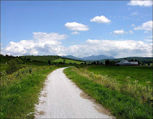
We will ride the rail trail for 2 miles and then cut over to Valley Road which is a smooth, scenic dirt road. The lupine were just starting to bloom in the fields last Monday, and if the rain hasn't hurt them, they should still provide a nice display for us as we ride by.
After 3 miles on Valley Road, we reunite with the rail trail again at its intersection with route 115 and follow it 4.5 miles into the Pondicherry Wildlife Refuge. This area has great scenery and panoramic views of the Presidentials. Magazine-worthy photographic opportunities. On the return, we can retrace our route or ride some pavement on Israel's River Road as a change of venue for awhile.
Total Mileage out and back: ~18.5 flat miles
Start time: 10:00 am, ready to ride .
For those heading to the Bowman parking area and wish to carpool, meet at the JacksonXC/Wentworth GC parking lot directly across from the J-Town Deli at 8:55am.
Bring water, lunch, camera and bug defense. A mountain bike is best for riding this relatively soft rail trail which often has short sections of coarse gravel.
For a map, click this link:
http://www.mapmyride.com/ride/united-states/nh/randolph/275124485600141373
Need more miles after looking out the window at the rain lately? If the weather is good, does anyone want to start at 8:30 to ride from the Pinkham B Road? This will add 18 miles to the day, adding a climb on Pinkham B and a ride on Durand Road, which is parallel to and North of Route 2. Durand Road ends about 1/2 mile before the Bowman trail parking area. Meet the rest of the riders at Bowman ready to ride at 10:00 after this "warm-up". Call or email Marianne for car pooling if you want to do these extra 18 miles: 383-9232 marianneborowski@yahoo.com.
Subscribe to:
Post Comments (Atom)


No comments:
Post a Comment