Fat Tire Cruisers has hit the end of the road. Thanks for the fun, friendship and adventures!!!
HAPPY TRAILS
Monday, October 12, 2015
Sunday, July 26, 2015
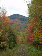
Gorham to Randolph on the Rail Trail
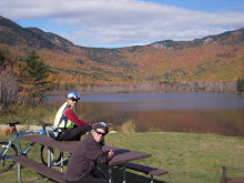
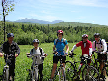
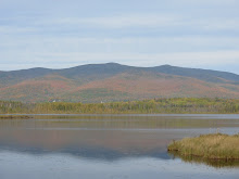
This gentle rail trail, on the old B&M rail bed, follows the Moose River through lovely woods with beaver ponds and meadows and some beautiful mountain views. From the Route 2 trail head we'll ride the old rail bed to the intersection of Pinkham B Road. Then we'll switch to Durand Road and take that to the rail trail's height of land at the Castle Trail in Bowman (Randolph). The ride back from Bowman on the rail trail is a blast as it is ever so slightly downhill. In all we'll cover about 20 miles. The surface of the trail is mostly dirt with some ballast and an occasional sandy spot.
Directions: Go north on Route 16 to Gorham. When route 16 meets route 2 at the T intersection turn left. Go through Gorham on Routes 16 and 2 until Route 2 diverges to the left at the traffic light . You'll see the trail head parking lot on the right about .8 mile after you turn left on Route 2.
Carpooling: Meet at the Old Jackson Town Hall at 8:20. We should start the ride in Gorham by 9:00am to take advantage of the cooler morning air.
Bring sunscreen, plenty of water and lunch. Please contact me by Monday evening if you plan to ride, we don't start the ride without you. Thanks.
Monday, July 6, 2015
Pondicherry
There weren't any takers on last week's ride so let's try again.
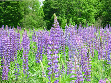
We’ll start at the western terminus of The Presidential Range Rail Trail and pedal through almost four miles of The Pondicherry National Wildlife Refuge where the views are absolutely magnificent. Then we’ll head for more open vistas on three miles of paved country road and another three miles on the dirt Valley Road. Then we'll turn right and we will return to Pondicherry on The Rail Trail. In all we’ll cover about 18 miles with breath taking mountain views and the panoply of wild flower filled fields.
The rail trail has a pretty firm surface and is a combination of dirt, gravel, stone, cinder and ballast. This is a relatively flat route with no major hills. It’s just a wonderful cruise through a beautiful area.
Directions: Take route 302 through Bretton Woods and at the traffic light go right on route 3 for 1.9 miles. Then take another right on route 115. In 4.4 miles Hazen Road will be on your left, take it. In another 1.4 miles there will be a dirt drive on the right which leads to a small perking lot.
Carpooling is a must due to the small parking lot at Pondicherry. Meet at 8:30am at the far west end of the Attitash parking lot.
Please let me know if you plan to ride.
Sunday, June 21, 2015
Monday Fat Tire Ride
Yes, that's right a Monday Fat Tire ride! Faced with another iffy Tuesday forecast I thought it would be a great idea to get ahead of the forecast and ride during tomorrow's sunny weather.
So how about meeting in the JXN Historical Society's parking lot at 9am and doing the Dam and Dummer ride? It starts across from the Berlin Airport and goes to the Pontook Dam and back.
Please let me know if you plan to ride.
Thanks, Joan
So how about meeting in the JXN Historical Society's parking lot at 9am and doing the Dam and Dummer ride? It starts across from the Berlin Airport and goes to the Pontook Dam and back.
Please let me know if you plan to ride.
Thanks, Joan
Monday, May 25, 2015
Dam, Dam, Dam, Dam, and Hot Dam
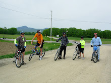
This favorite route, runs from the Gorham train depot to the Berlin eastern depot. It has a lot of variety, not to mention about five dams. We'll start off in downtown Gorham by the old train station and ride past the airport and then ride a mile through the back woods on the emergency access road which is closed to motorized traffic. After this we will be riding on the eastern end of the presidential rail trail to Berlin on the quiet and beautiful eastern bank of the Androscoggin River.
Along with getting great views of the Androscoggin we'll skirt a gravel pit, go over the very high trestle bridge across route 16 (this is always a thrill), bike by the hydroelectric powerhouse and dam on the canal adjacent to the Androscoggin, view the Cascade Flats complex and dam from the seldom seen east side and visit a waterfall, possibly for a lunch stop. This is probably the most beautiful fat tire cruiser lunch spot.
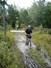
The changing surface of this easy, pretty flat ride consists of dirt, ballast, gravel and the occasional mud puddle. This 17 mile out and back route is appropriate for all abilities. The ride will start at 9:30 on Railroad Street across from the Gorham Town Common.
Carpooling: Meet at the Jackson Historical Society aka the Old Jackson Town Hall, parking lot (across from the post office) at 8:50.
Directions: Drive north on route 16 to Gorham. Just before the T intersection with route 2 there will be railroad tracks. Immediately after crossing the tracks turn left onto Railroad Street. Hook a U turn and park on the other side of the road across from the Common.
Please let me know before 8:00 tomorrow if you plan to ride and where you plan to meet the group.
Along with getting great views of the Androscoggin we'll skirt a gravel pit, go over the very high trestle bridge across route 16 (this is always a thrill), bike by the hydroelectric powerhouse and dam on the canal adjacent to the Androscoggin, view the Cascade Flats complex and dam from the seldom seen east side and visit a waterfall, possibly for a lunch stop. This is probably the most beautiful fat tire cruiser lunch spot.
The changing surface of this easy, pretty flat ride consists of dirt, ballast, gravel and the occasional mud puddle. This 17 mile out and back route is appropriate for all abilities. The ride will start at 9:30 on Railroad Street across from the Gorham Town Common.
Carpooling: Meet at the Jackson Historical Society aka the Old Jackson Town Hall, parking lot (across from the post office) at 8:50.
Directions: Drive north on route 16 to Gorham. Just before the T intersection with route 2 there will be railroad tracks. Immediately after crossing the tracks turn left onto Railroad Street. Hook a U turn and park on the other side of the road across from the Common.
Please let me know before 8:00 tomorrow if you plan to ride and where you plan to meet the group.
Tuesday, November 11, 2014
Monday, November 10, 2014
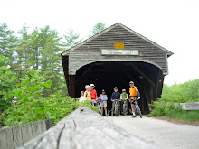
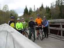
North Fryeburg to Hemlock Bridge
Last Call!
Let's meet at the No. Fryeburg Fire Station at noon to ride the roads (paved and dirt) of North Fryeburg. The views should be spectacular. We can figure out which route we want to take at the fire station.
Let's meet at the No. Fryeburg Fire Station at noon to ride the roads (paved and dirt) of North Fryeburg. The views should be spectacular. We can figure out which route we want to take at the fire station.
Subscribe to:
Posts (Atom)