It looks like we will have a window of opportunity this morning to ride. So let's get out there while we can. One report even says that we'll see blue skies when the fog burns off. All Right!
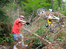
The trails we'll be riding today are by the Saco. The ground there is sandy and it drains quite well. So the trails should be in pretty good shape. During the last week I've been in there a few times and even with all the recent rain the trails were fine.
Tuesday, June 30, 2009
Monday, June 29, 2009
Rain Strain
Another forecast with a 50% chance of rain, ergh. Well let's think positively and plan for a ride tomorrow. How about another close to home ride in case we need to bail out (literally) early?
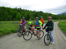
So let's explore the trails around and near Thorne Pond in Bartlett. These fun and virtually flat trails range from logging type roads to single track. While most of the trails are appropriate for an experienced novice, there will, occasionally, be quick turns, roots, stones and mud to ride around or over. There are a couple of spots where getting off the bike may be advisable. There aren't any difficult trails. So we should have a very nice ride.
We'll meet in the back of the Attitash parking lot, across route 302 from the mountain. Park in the back of the lot by the parking shack to avoid using spaces that Attitash customers might need. Be ready to ride at 10:00am.
Rain in the morning will cancel the ride. Check back here tomorrow morning around 8:00am to confirm that the ride is still on.
Monday, June 22, 2009
Tuesday June 23rd Ride
6/23 update...There's blue sky out there - Let's ride! See you at 10:00am.
Although the weather forecast is mixed, with a 50% chance of light rain, I'm feeling lucky. Let's get out and ride. Tomorrow's route will be an exploration of the dirt roads in the Bartlett Experimental Forest for about 5-8 miles (depending on the weather conditions). Then we'll cross over to the east side of Bear Notch Road and do some fun, experienced novice, single track and old logging roads on the Reservoir Brook Trail for 1.5 to 2 miles. We'll never be more than a few minutes away from our cars if it starts to rain and we decide to bail out of the rest of the planned route.
Let's meet at 10:00am, ready to go, in the parking lot off River Road just after it crosses the Saco River in Bartlett. Directions: Take Route 302 to Bartlett, at the blinking light in the center of Bartlett take a right and in about half a mile you'll cross the Saco River and the parking area will be to the left of the bridge.
We will need to shuttle people and bikes up to the top entrance of the Experimental Forest (which is almost at the top of Bear Notch) from the parking area. Then we'll start our mostly downhill adventure. Bring bug spray!
IF IT'S RAINING TOMORROW MORNING THE RIDE IS CANCELLED. Check back here at 8:00am to confirm cancellation.
Sunday, June 21, 2009
Lurking Murk
The weather for Tuesday is not "clear". However the tentative plan is to explore the forest roads in Bartlett's Experimental Forest and the Reservoir Brook Trail. But the weather seems to be up in the "air".
Check back here tomorrow night for more info and/or a more specific description of the ride if the weather looks acceptable.
Best Wishes, Joan
Check back here tomorrow night for more info and/or a more specific description of the ride if the weather looks acceptable.
Best Wishes, Joan
Sunday, June 14, 2009
A Hidden Jewel
A few years ago I was researching possible ride routes along the Presidential Range Rail Trail. None of the many maps and books I had (nor any of the websites I could find) was specific about the western terminus of the trail. So I organized a scouting group with Marianne Borowski and Glenn Ashworth and we went to the Pondicherry National Wildlife Refuge in Whitefield and Jefferson to explore. What we found was a gem, an incredibly beautiful place. Oh and we also found the western terminus of The Presidential Range Rail Trail.
So, now it's your chance to discover this beautiful spot. Marianne has chosen a really nice ride for you on Tuesday and I highly recommend it. Don't forget your camera!!!
Kudos to Marianne for her hard work! The following is her write up.
Lupine and Pondicherry by Rail Trail and Valley Road
The weather forecast looks great for Tuesday!
Let's do a scenic view ride in the Randolph-Jefferson valley area.
The route follows the Presidential Rail Trail for most of the way. It starts at the Bowman parking area (hikers parking for the Castle trail) on the left (south) side of Route 2.
From the Conway area, drive north over Pinkham Notch on route 16. Take a left onto Route 2, drive though town then take a left again on Route 2 as it heads west towards Randolph. Drive ~8.4 miles to the Bowman Castle Trail parking area, on the left. It is about 3 miles west of the Appalachia trail head parking area.
We will ride the rail trail for 2 miles and then cut over to Valley Road which is a smooth, scenic dirt road. The lupine were just starting to bloom in the fields last Monday, and if the rain hasn't hurt them, they should still provide a nice display for us as we ride by.
After 3 miles on Valley Road, we reunite with the rail trail again at its intersection with route 115 and follow it 4.5 miles into the Pondicherry Wildlife Refuge. This area has great scenery and panoramic views of the Presidentials. Magazine-worthy photographic opportunities. On the return, we can retrace our route or ride some pavement on Israel's River Road as a change of venue for awhile.
Total Mileage out and back: ~18.5 flat miles
Start time: 10:00 am, ready to ride .
For those heading to the Bowman parking area and wish to carpool, meet at the JacksonXC/Wentworth GC parking lot directly across from the J-Town Deli at 8:55am.
Bring water, lunch, camera and bug defense. A mountain bike is best for riding this relatively soft rail trail which often has short sections of coarse gravel.
For a map, click this link:
http://www.mapmyride.com/ride/united-states/nh/randolph/275124485600141373
Need more miles after looking out the window at the rain lately? If the weather is good, does anyone want to start at 8:30 to ride from the Pinkham B Road? This will add 18 miles to the day, adding a climb on Pinkham B and a ride on Durand Road, which is parallel to and North of Route 2. Durand Road ends about 1/2 mile before the Bowman trail parking area. Meet the rest of the riders at Bowman ready to ride at 10:00 after this "warm-up". Call or email Marianne for car pooling if you want to do these extra 18 miles: 383-9232 marianneborowski@yahoo.com.
Sunday, June 7, 2009
June 9th Ride
It looks like we'll be in for a period of rain starting Monday night. So the Tuesday June 9th ride is cancelled.
Next week the June 16th ride will be lead by the inimitable Marianne Borowski. She has been scouting out several possible ride routes especially tailored for our group. Check back this time next week to see what Marianne has in mind.
I'm "bugging out" of the valley and going to The Cape. Good by black flies and hello tick capitol of the world. I've got something a little different and special planned for the ride on June 23rd. It promises to be fun for the experienced riders and also fun for those who are newer to off road riding. Yup it'll have something for everyone. So stay tuned.
Happy Trails, Joan
Subscribe to:
Posts (Atom)