Gale River Rail Trail and Forest Loop
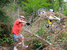
Wow a sunny forecast! Let's take this opportunity to do some exploring outside the confines of the valley. I've discovered a little known rail trail that parallels Trudeau Road in the National Forest in Bethlehem. Even better, this trail intersects one of Marty Basch's rides, the Gale Forest Loop, see page 146 of his book "The White Mountain Ride Guide" 2nd edition.
So put them together and what do you get? A 10 mile route which goes through the forest, along a portion of the Gale River and by scenic beaver ponds with great mountain vistas. Not a bad combo eh? The surfaces vary from dirt to grass with some sections of gravel. This ride is on the "harder side of easy" mostly due to the uphill portion of the forest loop. Feel free to join me in a short bike walk as we ascend to the top of the loop. The uphill is worth it though, as the next couple of miles are really fun.
The forecast is for temps in the mid 80s. It should be cooler in the woods. We will start the ride at 9:30 am sharp. Our trail head is just off route 302.
Carpooling - Meet at 8:30 am in the Attitash parking lot across the street from the lifts.
Directions - Take route 302 to Twin Mountain. Continue 5.0 miles north of the intersection of routes 302 and 3. Just past The Wayside Inn (which is on the left) is Muchmore Road. Go left and follow Muchmore Road for 0.1 mi as it bends around to the south. When the road pavement ends hook a U turn to park on the opposite shoulder by the old and closed blue bridge over the Ammonoosuc River. Park just south of the yellow fire hydrant.
Sunday, July 26, 2009
Sunday, July 19, 2009
A Valley Classic
Rob Brook Road Loop - Tuesday July 21st
The rains have subsided for the most part, so it's time to do a valley classic, The Rob Brook Road Loop. This does include a crossing of the Swift River towards the end of the ride and your feet will get wet. I checked out the crossing point on Saturday and it looks good. This is a 12 mile ride, suitable for all abilities, mostly on a winding dirt forest road with the last few miles on the Kanc and Bear Notch Road. There are hills to climb and they are quite doable. The last hill is just before we get back to our cars and I'll be happy to walk up that one with any others who are so "inclined".
You can find a more complete description of the route on pages 36 to 38 of Marty Basch's "The White Mountain Ride Guide" 2nd edition. A good lunch spot is at The Russell Colbath House (on The Kanc) where there are picnic benches by the barn.
The Trail Head and parking are on the west side of Bear Notch Road .75 mi north of the intersection with The Kanc. This is not a fee area of The White Mountain National Forest these days. Humid air is headed our way so let's get an earlier start. We will leave the parking area at 9:30 sharp.
Monday, July 6, 2009
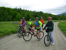
Tuesday July 14th Ride
Gorham to Berlin on the Rail Trail - We've explored two sections of the Presidential Rail Trail and we have one section left to go. This scenic segment runs from the parking lot in Gorham on route 2 to Berlin along the east (quiet) side of the Androscoggin River. This lesser know rail trail has several interesting features. Along with getting great views of the Androscoggin we'll skirt a gravel pit, go over the very high trestle bridge across route 16, bike by the hydroelectric powerhouse and dam on the canal adjacent to the Androscoggin, view the Cascade Flats complex and dam from the seldom seen east side and visit a waterfall, if I can find the side trail again.
When I took this route last fall the surface was varied. It consisted of dirt, ballast, gravel and the occasional mud puddle. There was one section of loose stones that some may choose to walk their bikes across but it was possible to safely ride this section. This 10.5 mile out and back route is appropriate for all abilities. There might be the odd ATV or dirt bike as I saw their tracks but did not encounter one these vehicles. After our return from Berlin we will have the opportunity to explore the 1 mile emergency road which begins across route 2 from our starting point. For those who might want to cover more miles there is the option to ride west on the rail trail too.
The Trail Head and parking is on Route 2 in Gorham. Directions: go north on route 16 to Gorham. When route 16 meets route 2 at the T intersection turn left. Go through Gorham on Routes 16 and 2 until Route 2 diverges to the left at the traffic light . You'll see the trail head parking lot on the right about .8 miles after you turned left on route 2. For those of you who want to carpool meet at The Old Town Hall in Jackson, across the road from the post office at 9:00am. Be ready to ride at 10:00am at the trail head in Gorham and hope for a beautiful sunny summer day.
Want to view a map of this ride? Click below.
http://www.mapmyride.com/ride/united-states/nh/-gorham,-nh/451124594135949120
Next weekend Marty Basch will present an entertaining look at life from the seat of a bicycle on Saturday, July 18 at 7 PM at the Whitney Center in Jackson. Marty has recently published a second edition of the popular The White Mountain Ride Guide which includes both road bicycling trips and mountain bike trails. This program is free.
Sunday, July 5, 2009
Stay Tuned
Presently the chance of rain for Tuesday is 60%. So check back tomorrow night. We may be able to ride Tuesday morning before the instability in the atmosphere creates showers. Tough telling not knowing.
Subscribe to:
Posts (Atom)