Saturday, November 24, 2012
Monday, November 12, 2012
Sunday, November 4, 2012
Tour de North Conway
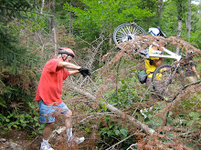
Is there anybody left who wants to ride on Tuesday? We have a fun route that loops around North Conway starting and ending at the Scenic Vista. It's mostly in the woods on dirt trails.
The weather forecast calls for sunny skies and little wind. The temperature during ride time is projected to be in the low forties. To get the best out of the day the start time would be an hour or two later than usual.
Please let me know if you'd like to ride on Tuesday. Thanks
The weather forecast calls for sunny skies and little wind. The temperature during ride time is projected to be in the low forties. To get the best out of the day the start time would be an hour or two later than usual.
Please let me know if you'd like to ride on Tuesday. Thanks
Sunday, October 28, 2012
Sunday, October 21, 2012
Sweet Success
The circumnavigation of Success Pond is another great ride. Our starting point will be at the Goose Eye Trailhead on Success Pond Road which starts on the east side of Berlin. The first part of the ride is on Success Pond Road which is dirt and mostly flat with occasional brief minor hills. The best part of the road is that it is surprisingly open which will give us panoramic views.
Next we'll pedal into Success Pond for an exploration around the east side of the pond. Then we’ll go left on Black Strap Road and take the second trail to the left after crossing the brook. There is a sign here that prohibits ATVs. We’ll follow this trail back towards the pond. As we head back to Success Pond Road we will encounter one long uphill that's quite a workout. It is however quite walkable.
Let’s meet at the old Jackson Town Hall at 9:30am. We’ll then drive to Berlin on route 16 and cross over to the east side of The Androscoggin on the Unity Street Bridge which diverges to the right a little bit before downtown Berlin. Continue north on Hutchins Street towards the site of the old paper mill which you will pass on the left. As I recall Success Pond Road will be on the right just after the Berlin Dumpsite.
In all we’ll cover about 18 miles on dirt roads and snow mobile trails. Expect the unexpected: wet areas, mud, moose, etc. The plan is to start the bike ride at 10:30 at the Goose Eye Trailhead on Success Pond Road. Don’t forget your lunch.
Please let me know if you plan to ride with us on Tuesday.
Sunday, October 14, 2012
Harmon Notch
It's time to try out the newly extended rail trail in Fryeburg and have a really pretty ride through a notch that most of us
have never heard of. Harmon Notch is located between Peary Mountain and Frost
Mountain. The best part is that it’s only a 175’ elevation gain.
The starting point for this ride is at The Maine Information Center on route 302 in Fryeburg. We’ll head east on the rail trail to Porter Road and then ride south to Farnsworth. Soon after we’ll hop onto a jeep track that crosses the Little Saco and then head to Haleytown Road.
At Hampshire Road we’ll go left and head in the direction of a dirt road called Peary Mountain Road which morphs into Harmon Notch Road. After the last house this road gets narrower and towards the notch area there is about a mile of jeep track that could benefit from better drainage, fewer rocks and some smoothing out. Don’t let this “spook” you it’s no harder than other rides we’ve done and you can always dab and walk. After going through the notch the trail heads downward to a different section of Farnsworth Road and then we will head west. Then we’ll head north on Porter Road and take a right onto Clay Pond Road toward the airport and just beyond we'll connect to the new section of the Mountain Division Rail Trail in Fryeburg and head back to our starting point. In all we'll cover about 18 miles and get a really good workout.
Carpooling – Meet at the scenic overlook in North Conway at 9:30am. We’ll start the ride at 10am from the Maine info center. Don’t forget to bring a lunch.
Please let me know if you expect to do this ride. Several of our regulars are away and it could be cancelled due to lack of participation.
Sunday, October 7, 2012
Stone House Loops in Evans Notch
This is Bob's favorite ride and with good reason . Every year the foliage is magnificent and the scenery is spectacular. We will have Evans Notch pretty much to ourselves with hardly any traffic.
This route first loops around Deer Hill on; route 113, Stone House Road, Shell Pond Trail, a bit of Shell Pond Loop Trail and Deer Hill Road. Most of the loop will be on dirt roads or trails. There will be one trail segment that is a bit rough but doable (and quite walkable for those who choose to) especially where we will link up to Deer Hill Road from the Shell Pond area. Then we'll make another loop as we head up to the Bricket Place and on to The Basin for a lunch amid the eye popping scenery. And then it's back to our cars via route 113.
We’ll start the ride at the Forest Service parking lot which is about .10 mi north of the AMC Cold River Camp entrances on the right side of route 113. Meet for car pooling at the Scenic Vista parking lot in North Conway, at 9:00. We should be ready to start the ride at about 10:00am. If you plan to drive right to the trail head please let me know. Thanks
Saturday, September 29, 2012
Rob Brook Road Redux
If the weather cooperates how about a ride on Rob Brook Road? Two weeks ago this ride was posted, but Fred was the only one to show up. Kudos to Fred! So let's try to do it again. Check back Tuesday around 8am if the weather looks iffy.
The Rob Brook Road Loop is a valley classic. This area has a reputation for being buggy. Three years ago when we rode this route in July it lived up to its reputation. But the bugs have left us for the most part and its time we got out there for a very pleasant ride. This is a rolling 12 mile ride, suitable for all abilities, mostly on a winding dirt forest road with the last few miles on the Kanc and Bear Notch Road. There are small hills to climb and even though it's one of our shorter rides. you (and your gears) will get a good workout on this ride.
Marty Basch describes this ride in his White Mountain Ride Guide as follows "The road winds by streams and huge boulders. Spotting signs of moose and deer are common. A few quick climbs are rewarded with refreshing downhills."
Plan on getting your feet wet as you need to cross the Swift River to get to the Kanc. You may want to bring an extra pair of shoes to get you across the river. Just after you cross the river look slightly right and follow that path a short way to the Kanc. Go left (east) on the Kanc.
A good lunch spot is at The Russell Colbath House (on The Kanc) where there are picnic benches by the barn. After lunch continue eastward on the Kanc until Bear Notch Road appears on the left.
The Trail Head and parking are on the west side of Bear Notch Road .75 mi north of the intersection with The Kanc. Meet at the trailhead at 10:00am.
Sunday, September 23, 2012
Pondicherry
The weather forecast looks great for Tuesday September 25th! Let's do an amazingly
scenic ride in Jefferson and check out the fall colors.
We’ll start at the western terminus of The Presidential Range Rail Trail and pedal through almost four miles of The Pondicherry National Wildlife Refuge where the views are absolutely magnificent. Then we’ll head for more open vistas on three miles of paved country road and another three plus miles on the dirt Valley Road. When we reach Jefferson Notch Road we will return to Pondicherry on The Rail Trail. In all we’ll cover about 18 miles with breath taking views and the fall foliage colors.
The rail trail has a pretty firm surface and is a combination of dirt, gravel, stone, cinder and ballast. This is a relatively flat route with no major hills. It’s just a wonderful cruise through a beautiful area.
Directions: Take route 302 through Bretton Woods and at the traffic light go right on route 3 for 1.9 miles. Then take another right on route 115. In 4.4 miles Hazen Road will be on your left, take it. In another 1.4 miles you will see a sign on the right saying Presidential Recreation Trail Pondicherry. Go right into the small parking lot. We may have to do some creative parking to fit us all in here.
Carpooling is a must due to the small parking lot at Pondicherry. Meet at 9:00am at the far west end of the Attitash parking lot. Please be ready to ride at 10:00am.
Click here for a map of this ride.
http://www.mapmyride.com/routes/view/11313897
Sunday, September 16, 2012
Rob Brook Road
If the weather cooperates how about a ride on Rob Brook Road? I'm still on The Cape so I won't join you until next week. Here's the description.
The Rob Brook Road Loop is a valley classic. This area has a reputation for being buggy. Three years ago when we rode this route in July it lived up to its reputation. But the bugs have left us for the most part and its time we got out there for a very pleasant ride. This is a rolling 12 mile ride, suitable for all abilities, mostly on a winding dirt forest road with the last few miles on the Kanc and Bear Notch Road. There are hills to climb but they are quite doable.
Marty Basch describes this ride in his White Mountain Ride Guide as follows "The road winds by streams and huge boulders. Spotting signs of moose and deer are common. A few quick climbs are rewarded with refreshing downhills."
Plan on getting your feet wet as you need to cross the Swift River to get to the Kanc. Just after you cross the river look slightly right and follow that path a short way to the Kanc. Go left (east) on the Kanc. A good lunch spot is at The Russell Colbath House (on The Kanc) where there are picnic benches by the barn. After lunch continue eastward on the Kanc until Bear Notch Road appears on the left.
The Trail Head and parking are on the west side of Bear Notch Road .75 mi north of the intersection with The Kanc. Meet at the trailhead at 10:00am.
Saturday, September 1, 2012
Monday, August 20, 2012
Wild River Ride
It's been almost a year since Irene ripped through the White Mountains and the Wild River lived up to it's name. Last year we viewed the awesome changes that resulted from the deluge in the Wild River Valley. One of the suspension bridges across the river was completely blown out, the other survived although it also was damaged. The dirt Wild River Road was washed out in many places and the campground was not there anymore. The Wild River Trail which went from the campground into the Wilderness Area was underminded and gouged out on the way to a gargantuan mass of trees and other debris which created an impenetrable wall that cut off the trail.
This Tuesday August 21st, let's revisit the beautiful Wild River Valley and see what The Forest Service and it's contractors have been up to in the last 51 weeks. The road has been rebuilt and the campground is back in action, but I bet that staggering mountain of trees and debris is still there. Check out the Forest Service's website which has before and after photos of Wild River Road.
http://www.fs.usda.gov/Internet/FSE_DOCUMENTS/stelprdb5382177.pdf
From the ride's starting point on Route 2 just before the intersection of Route 113 we'll ride about 3 miles up to Wild River Road. We may encounter a few cars on Route 113, but weekday traffic should be light. As we bike the almost 6 miles to the campground we’ll still get a sense of the force of the flood waters and the large scale repairs that have been made. In all we’ll cover something like 18 miles on this out and back ride. This ride generally follows the old Wild River Railroad route into this area. So the riding is pretty easy although it isn't flat and there are some hills. As we go into the valley the road rises gradually and the return is a very fun downward ride.
Directions: Go to Gorham on route 16 north. At the Route 2 intersection go right toward Maine. About 2 (I think it’s 1.9) miles beyond the Maine State line take a right onto a dirt road which leads to the site of the old bridge and a large parking area. If you get to the new bridge which is just beyond our turn off you’ve gone too far. And if you get to Route 113, on the right, just over the new bridge you’ll know you’ve over shot the starting point.
Let’s start the ride at 10:00am. It’s going to be a beautiful day and we can have a picnic lunch along the river. If anyone wants to carpool meet at the Jackson Old Town Hall parking lot across from the post office at 9am. Don't forget to bring your lunch and some water.
Monday, August 13, 2012
Gorge(ous) Lovell
It’s the height of the tourist season. Has anyone else noticed the epic backups going into and out of North Conway? So tomorrow, August 14th, we need to get far from the madding crowds. And there’s nowhere more remote and scenic as the Kezar Falls Gorge /Five Kezar Ponds area out of Lovell, Maine. You’ll be surprised at the remoteness of the second half of the ride.
We'll start out at the Lovell Historical Society and take Old Waterford Road to Kezar Falls Gorge, which Delorme rightly describes as a unique natural area. Then the route will take us to the Five Kezar Ponds where we’ll take a path around one. Next we’ll retrace our tracks back down Old Waterford Road to a dirt road and head out to the Dan Charles Pond area and then after a series of dirt roads (with a couple of sandy spots) we’ll come out on Fern St which will lead us back to Old Waterford Road and the Historical Society. After the heavy rains on Friday we may encounter puddles etc.
There are a few hills, primarily at the beginning of the ride so we’ll get our most aerobic exercise during the cooler part of the day. Otherwise the terrain will be relatively easy to cover. The surface will be pavement, pavement reverting to dirt, dirt and packed sandy soil. We should cover a bit over 19 miles. Bring lunch, water and sunscreen.
Added Bonus: The Historical Society will be open Tuesday so you can nip in there for a look see at the exhibits after the ride.
Please be ready to ride at 9:30am. Park in the lot/field which is on the left, just across from the historical society building which is 1.5 miles past the intersection of routes 93 and 5 in Lovell. To get to Lovell take route 5 north out of Fryeburg, Me.
Carpooling: Meet at the Scenic Overlook in North Conway which is conveniently located across the street from Trails End Ice Cream Shop. Meet Time 8:40am
Monday, August 6, 2012
Ammonoosuc Rail Trail
Last year we didn’t get to this ride which is a shame since it is goes
through such beautiful countryside. It
is a multi-use rail trail that runs about 20 miles between Woodsville and
Littleton along the Ammonoosuc River. Tomorrow we'll ride the northern half of
the trail from Littleton to Lisbon for about 20 miles out and back, on this
almost flat route which wends its way through bucolic woods and farm lands by
the Ammonoosuc River. If you are so
inclined, you can cool off in the Ammonoosuc after the ride at the very scenic
swimming hole next to the lot where we’ll park our cars. Bring a towel and a change of clothes.
Littleton is a neat little town. After we ride we can visit Bishops Homemade Ice Cream Shop. Yankee Magazine rated it one of the top five ice cream stands in New England. Need I say more? Also there's Chuttters which boasts the "world’s longest candy counter". Even if you’re not a big candy fan it is quite a sight and worth a visit. Other historic points of interest include Thayers Inn which was built in 1850. Common areas and a couple of rooms are open for viewing. Five Presidents and countless celebrities and national politicians have been guests at Thayers Inn. And there's the Littleton Grist Mill which is a restored 1798 mill and museum. All of these attractions are in the bustling downtown area and are a short walk from our cars which will be parked behind the Littleton Bike shop in their parking lot.
Bring: plenty of water, sunscreen, and lunch
Carpooling: Meet at 8:45am in the Attitash parking lot at the very west end far away from where the Attitash summer patrons usually park their cars. We will start the ride by 10:00am. Please let me know if you plan to meet the group in Littleton, so that we don’t start without you.
Directions: Take route 302 northwest to Bethlehem and get on route 93 northbound. At exit 41 head north on route 302 towards downtown Littleton. In about ¾ of a mile The Littleton Bike Shop will be on the left. It is 23 Cottage Street (route 302). Take the driveway/road just before the bike shop building and park in back.
Sunday, July 29, 2012
Experimental Forest and Reservoir Brook Trail
This Tuesday Barbara has invited us back to her house after the ride for
refreshments and a dip in her pool for those who are so inclined. To keep the driving and logistics to a minimum
let’s do a local ride - The Experimental Forest and Reservoir Brook Trail
ride.
We'll start off at the top of Bear Notch Road and cruise down the dirt roads in the Bartlett Experimental Forest. Then we'll cross over to the east side of Bear Notch Road and do some fun single track and old logging roads on the Reservoir Brook Trail.
In all we’ll cover less than 10 miles. For those of you who want to add to your mileage you could meet us at the top of Bear Notch between 10:15 and 10:30. Or you could pedal to Barbara’s after the ride. Or you could add some miles by biking on River Road before the ride.
Let's meet at 10:00am, in the parking lot off River Road just after it crosses the Saco River in Bartlett.
Directions: Take Route 302 to Bartlett, at the blinking light in the center of Bartlett take a right and in about half a mile you'll cross the Saco River and the parking area will be to the left of the bridge.
Bring your lunch to eat at Barbara’s. Also pack water, sunscreen and bug spray.
We will need to shuttle people and bikes up to the top entrance of the Experimental Forest (which is almost at the top of Bear Notch) from the parking area. Then we'll start our mostly downhill adventure.
Monday, July 23, 2012
Dam, Dam, Dam, Dam and Hot Dam!
This favorite route, runs from the Gorham train depot to the Berlin eastern depot. It has a
lot of variety, not to mention about five dams. We'll start off in downtown
Gorham by the old
train station and ride past the airport and then ride a mile through the backs
woods on the emergency access road which is closed to motorized traffic. After
this we will be riding on the eastern end of the presidential rail trail to
Berlin on the quiet and beautiful eastern bank of the Androscoggin River.
Along with getting great views of the Androscoggin we'll skirt a gravel pit, go over the very high trestle bridge across route 16 (this is always a thrill), bike by the hydroelectric powerhouse and dam on the canal adjacent to the Androscoggin, view the Cascade Flats complex and dam from the seldom seen east side and visit a waterfall, for a lunch stop. This is probably the most beautiful fat tire cruiser lunch spot.
The changing surface of this pretty flat ride consists of dirt, ballast, gravel and the occasional mud puddle. This 17 mile out and back route is appropriate for all abilities. The ride will start at 10:00 on Railroad Street across from the Gorham Town Common.
Please Note: Check back here tomorrow morning around 8am if the weather looks iffy.
Carpooling: Meet at the Jackson Historical Society aka the Old Jackson Town Hall, parking lot (across from the post office) at 9:20.
Directions: Drive north on route 16 to Gorham. Just before the T intersection with route 2 there will be railroad tracks. Immediately after crossing the tracks turn left onto Railroad Street. Hook a U turn and park on the other side of the road across from the Common.
To view a map of this ride click below.
http://www.mapmyride.com/routes/view/20611220
Sunday, July 15, 2012
Echo Lake and Moat Mountain Loop
It’s
the middle of summer and Tuesday’s forecast is for a hot and muggy day. So what do you say we do a mellow ride with
plenty of shade? The Echo Lake and Moat
Mountain loop fits this bill nicely.
The
starting point will be the parking lot just outside Echo Lake State Park in North
Conway. From there we'll ride south on
West Side Road for about 3 miles and then enter The National Forest on a trail
in the Cedar Creek Development. As an
added feature, we’ll see the new signs which mark the trail heads and junctions
of the Moat Mountain biking system.
These were installed recently by our very own White Mountain NEMBA
Chapter in cooperation with The Forest Service.
After entering the Moat Mountain area we’ll take the old rail trail to the top of the quarry for some great views. After retracing our way back to Forest Road 379A we’ll head in the general direction of Echo Lake.
After entering the Moat Mountain area we’ll take the old rail trail to the top of the quarry for some great views. After retracing our way back to Forest Road 379A we’ll head in the general direction of Echo Lake.
Most
of this ride is pretty flat and suitable for all abilities. So for those of you
who are fairly new to fat tire riding this would be a great ride. We will cover
about 4 miles of pavement and 6-8 miles of dirt forest trails.
Meet at 9:00am in the parking lot just outside and to the left of the gates to Echo Lake State Park in North Conway. Bring bug spray, a snack or lunch and sun screen. See you there.
Meet at 9:00am in the parking lot just outside and to the left of the gates to Echo Lake State Park in North Conway. Bring bug spray, a snack or lunch and sun screen. See you there.
Sunday, July 8, 2012
Presidential Rail Trail - Gorham Side
It looks like Tuesday July 10th is going to be a wonderful day for a ride. So it'll be a great day to ride the eastern end of the gentle and very scenic Presidential Rail Trail.
This easy trail, on the old B&M rail bed, will take us through lovely woods with beaver ponds and meadows and some beautiful mountain views. From the Route 2 trail head we'll ride the old rail bed to the intersection of Pinkham B Road. Then we'll switch to Durand Road and take that to the rail trail's height of land at the Castle Trail in Bowman (Randolph). The return journey will be wholly on the rail trail.
The ride back to our starting point will be a breeze as it is ever so slightly downhill. In all we'll cover about 20 miles. The surface of the trail is mostly dirt with some ballast and an occasional sandy spot. We usually ride this trail earlier in the season as it is a good "starter trail". But we had all rainy Tuesdays in May.
Directions: Go north on Route 16 to Gorham. When route 16 meets route 2 at the T intersection turn left. Go through Gorham on Routes 16 and 2 until Route 2 diverges to the left at the traffic light . You'll see the trail head parking lot on the right about .8 mile after you turn left on Route 2.
Carpooling: Meet at the Old Jackson Town Hall at 9:15. We should start the ride in Gorham by 10:00am.
Bring sunscreen, plenty of water and a snack (or lunch). For those who are interested in amazingly good panninis, we can go to Saladino's in downtown Gorham for lunch after the ride.
Monday, July 2, 2012
Warren Rail Trail
Last
year we didn’t get to this really nice ride. Recently there was a request to try this route
again and I couldn’t agree more. It’s time to do this scenic and varied rail
trail again. Its going to be a warm
summer day tomorrow so this shady, woodsy ride will fit the bill
perfectly. Below is the trail
description from the Rails to Trails Conservancy’s website.
“This popular trail starts from an interesting landmark: a Redstone missile brought to Warren by a resident who served in the Army in Alabama in 1970. He found some obsolete missiles in a field and arranged with the Army to transport one back to Warren, aiming to bring something of America's thriving (and far-removed) space program closer to local youth. Placed in the town center in 1971, it remains a prominent fixture.
The rail-trail (a.k.a. the Jesse E. Bushaw Memorial Trail or New Hampshire Snowmobile Corridor No. 5) is a pleasant and picturesque 9.4-mile multipurpose route. The hard-packed dirt surface is generally wide, smooth, and flat, and motorized use is permitted, making it popular among ATV riders in summer and snowmobilers in winter. The trail also welcomes walkers, bikers, equestrians, and anglers eager to try their luck in trailside brooks and ponds.
While most of the route is straight with few technical obstacles, between miles 6 and 7, the trail dips and climbs steeply as it diverges from the railbed to follow State Route 25. Where it rejoins the corridor, the route again runs straight and flat.
Around mile 8, just after you pass the concrete cubes protecting this section of the trail from motorized use, you'll enter the Oliverian Valley Wildlife Preserve's Habitat Management Demonstration Area. Viewing platforms on either side of the path help you keep an eye out for birds and other wildlife. In the final mile, the trail passes under power lines, swings to the right, and crosses a brook. You'll emerge on State Route 25 in East Haverhill."
Directions: Take the Kanc (route 112) to North Woodstock go across route 3 and continue on route 112 for 2.6 miles. Take a left onto route 118 which will take you to Warren. Look for the upright missile in downtown Warren and we'll figure out parking from there.
Carpooling: For those people who will use Bear Notch Road meet at the Attitash parking lot at 8:45am. We should be ready to start the ride around 10am. If you plan to drive directly to Warren please let me know. Just to make sure that we don’t ride off without you.
Map link:http://www.mapmyride.com/ride/united-states/nh/-warren/897125621736444678
Bring plenty of water, lunch and bug spray.
Monday, June 25, 2012
Sunday, June 17, 2012
Wild River Ride
This Tuesday, June 19 we'll ride the Wild River road to the campground from Route 2.
Directions: Go to Gorham on route 16 north. At the Route 2 intersection go right towards Maine. About 2 (I think it’s 1.9) miles beyond the Maine State line take a right onto a dirt road which leads to the site of the old bridge and a large parking area. If you get to the new bridge which is just beyond our turn off you’ve gone too far. And if you get to Route 113, on the right, just over the new bridge you’ll know you’ve over shot the starting point.
We’ll meet at 10 am in the parking lot. Bring a lunch and we’ll eat somewhere along the river.
Monday, June 11, 2012
Dam and Dummer
Tomorrow looks like a stellar day for a bike ride. And we deserve it too. So to celebrate our good fortune let’s do one
of our very best rides.
This fabulous ride starts across the street from the Berlin
Airport. First we'll pedal north on the rural and quiet East Side River Road which
closely follows the Androscoggin River and has wonderful views. Next we'll turn
right onto Hill Street, a dirt road which gently rises through woods and farm
lands and takes us on a loop with great southern views and back to East Side
River Road. From here we'll ride to dirt roads which parallel a hydropower
canal before getting us to the seldom visited east side of the Androscoggin
River. Before starting our return on East Side River Road we'll stop for a
water front lunch at either the dam or the hydro station south of the dam.
To see the map of this 18 mile part pavement and part dirt road ride click here: http://www.mapmyride.com/routes/view/17313468
Driving directions:Take route 16 north through Berlin. About 3 miles past the Nansen Wayside Park (old ski jump on the left and waterfront park on right), Bridge Street will be on the right. You should also see an airport sign pointing right too. Cross over the Androscoggin River and at the end of Bridge Street pull into the ball park lot on your left.
Carpool: Meet at 8:45am at The Old Jackson Town Hall which is across the street from the Post Office.
If you plan to meet the group at the starting point please let me know, chumley@earthlink.net so that we don't start the ride without you. Please be ready to ride a little bit before 10:00am tomorrow. See you there for a very special ride.
Monday, June 4, 2012
To Ride or Not to Ride...
CANCELLED
It’s cold, it’s damp and showers are expected. Dangity!!!
We've been washed out for five weeks in a row. Will the sixth time be the charm? Stay tuned. The NWS say there's a 40% chance of rain tomorrow. If the skies do clear for a ride, let's do The Presidential Rail Trail from Gorham. See last week's description.
Check back tomorrow after 8am for the scoop and the timing.
Monday, May 28, 2012
Last Chance to ride in May
CANCELLED
Can you hear that thunder and see the lightening and torrential rain? This is the fifth cancelled Tuesday ride in a row. Five Tuesday rides flushed down the drain. UGH!
-------------------------------------------------------------
Well it looks like another inconclusive weather forecast. So we may or may not be able to get in a ride. If by some chance it looks ok for a ride in the morning meet at the parking lot in front of Old Town Hall in Jackson (across the street from the Post Office) at 9:15. Check back in the morning about 8am for an update. Rain will cancel. If the weather does turn in our favor I was thinking about doing the Presidential Rail Trail in Gorham. It's a good early season route as it's a gentle and scenic ride.
This easy trail, on the old B&M railbed, will take us through the woods with beaver ponds and meadows and some beautiful mountain views. From the Route 2 trail head we'll ride the old rail bed to the intersection of Pinkham B road. Then we'll switch to Durand Road and take that to the rail trail's height of land at the Castle Trail in Bowman (Randolph). The return journey will be wholly on the rail trail. The ride back to our starting point will be a breeze as it is ever so slightly downhill. In all we'll cover about 20 miles.
Directions: Go north on Route 16 to Gorham. When route 16 meets route 2 at the T intersection turn left. Go through Gorham on Routes 16 and 2 until Route 2 diverges to the left at the traffic light . You'll see the trail head parking lot on the right about .8 miles after you turned left on Route 2.
Monday, May 21, 2012
Ride Cancelled, Again
Tuesday May 22
Yikes! Not another cancellation! The weather just will not cooperate. Let's hope for sunshine next Tuesday!
Sunday, May 13, 2012
Monday, April 30, 2012
MAY DAY !!!
Cancelled
There is, at present, an 80% chance of rain for Tuesday in Gorham (it's 90% and 100% in Jackson and North Conway respectively). So we may or may not be able to get in a ride. If the weather turns in our favor I was thinking about doing the Presidential Rail Trail in Gorham. It's a good early season route as it's a gentle and scenic ride.
There is, at present, an 80% chance of rain for Tuesday in Gorham (it's 90% and 100% in Jackson and North Conway respectively). So we may or may not be able to get in a ride. If the weather turns in our favor I was thinking about doing the Presidential Rail Trail in Gorham. It's a good early season route as it's a gentle and scenic ride.
If by some chance it looks ok for a ride in the morning meet me in the parking lot in front of Old Town Hall in Jackson (across the street from the Post Office) at 9:15. Rain will cancel. Check back in the morning by 8am for an update.
Sunday, April 22, 2012
Harbor to Hemlock
Judy and Joe will be leading this week's ride in North Fryeburg on Tuesday April 24th. It will start across the street from the North Fryeburg Fire Station and go to The Hemlock Covered Bridge. This easy out and back ride will cover about 15 very scenic miles on Fish St, MacNeil Rd, River Rd, Frog Alley and Harbor Rd. You will ride on paved and dirt roads.
At present there is a 50% chance of rain on Tuesday so Judy and Joe will send out an email on Monday with a go or no go notice. And if the ride is on they will set a time to start the ride.
Park next to the Saco Valley Fire Station in North Fryeburg, at the corner of Route 113 and South Chatham Road. Do not park in front of the fire station, park on the side of the road next to the park.
Have fun and don't forget to bring a lunch.
SAVE THE DATE - During last week's ride the group decided to hold the April Dinner on Monday April 30th at The Cider Mill for their Beer and Burger Monday night special.
Monday, April 16, 2012
2012 - Let's Cruise!
Tuesday looks like a beautiful day for our first ride of the 2012 season. So how about something new and easy to get us started? York Pond Road in the WMNF in Berlin should be perfect for our first outing. We'll go out and back and cover 13 miles of part paved and part dirt surface in a pretty and infrequently visited section of the WMNF. On our way back we can check out the Berlin Fish Hatchery which is located on York Pond Road.
If you'd like to carpool meet at The Old Jackson Town Hall (across from the Post Office) at 9:00am. We should start the ride just after 10:00am. Don't forget to bring a lunch and wear sunscreen.
Directions - Go north on route 16 to Berlin. Just after the road becomes one way in downtown Berlin go left on route 110. Follow 110 for about 7+ miles to York Pond Road on the left hand side. Go 1.5 miles on York Pond Road to the point where FR 15 forks to the left. Take FR 15 and park up on the right in a large dirt parking lot.
Subscribe to:
Posts (Atom)