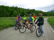
Here’s a brand new ride! And it’s a notch ride. What? A fat tire notch ride you say? Yes indeedy! This is a really pretty ride through a notch that most of us have never heard of. Harmon Notch is located between Peary Mountain and Frost Mountain. The best part is that it’s only a 175’ elevation gain and most of the climb is on a good section of dirt road. What a cheap date!
The starting point for this ride is at The Maine Information Center on route 302 in Fryeburg. We’ll head south on Haleytown Road which has been recently repaved and there’s not enough O’s in smooth to do it justice. Then it’s left on Farnsworth, which is a dirt road, and after a mile or so we’ll hop onto a jeep track that crosses the Little Saco and then heads back to Haleytown.
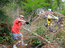
At Hampshire Road we’ll go left and head in the direction of a dirt road called Harmon Notch Road. After the last house this road gets narrower and towards the notch area there is a half mile section that could benefit from better drainage and fewer rocks. Don’t let this “spook” you it’s no harder than other rides we’ve done. And for some of us it will provide an excellent opportunity to walk our bikes. We’ll come out on a different section of Farnsworth Road and head west. Then we’ll head north on Porter Road (dirt) and take the newly constructed Mountain Division Rail Trail in Fryeburg back to our starting point.
Wear bright clothes, it is hunting season. I didn’t see any hunters in this area when I was scouting this ride, but it’s best to be bright this time of year. In all we should cover about 16 – 17 miles. Dress warmly. Expect mud and perhaps a bit of left over snow.
Carpooling – Meet at the scenic overlook in North Conway at 10:20am.
We’ll start the ride at 11am from the Maine info center. Don’t forget to bring a lunch.
Monday, October 31, 2011
Monday, October 24, 2011
Tour de Gorham
Here’s another fun ride for you this Tuesday. This perennial favorite is about a 14 mile circumnavigation of Gorham on mostly dirt roads and trails with a bit of paved road thrown in too. The starting point is at the route 2 parking lot for the Presidential Rail Trail.
We’ll start out on the gravel Gorham Emergency Road which is closed to motorized vehicles except in (you guessed it) emergencies when Route 2 through the center of town is impassable. At the airport we’ll get onto the pipeline trail which will take us by the south side of the airport thus avoiding the roads of downtown Gorham. After about a mile we’ll cross route 16 and take a residential road to a foot bridge across the Peabody River and get back on the pipeline trail. Here there will be a short but very steep hill to walk up with the bikes. And then it's a pretty much of a straight shot on the pipeline trail back to Route 2 and North Road. There is the option to leave the pipeline trail at various points and take Route 2 if the group prefers a smoother paved surface for this segment of the Tour de Gorham.
As we cross over the Androscoggin River we can view the progress to the repairs on the Shelburne Dam which was seriously damaged by Hurricane Irene. Next we’ll follow Hogan Road west for about 5 miles on the virtually untraveled north side of the Androscoggin River where there will be awesome views of the river and several power dams. Then we’ll take a left onto the Presidential Rail Trail which will take us back to our cars. Most of this ride will be on pretty flat and smooth trails and roads. The exception is the pipeline trail which has rolling hills and several excellent opportunities to walk the bikes.
Directions: Go north on Route 16 to Gorham. When route 16 meets route 2 at the T intersection turn left. Go through Gorham on Routes 16 and 2 until Route 2 diverges to the left at the traffic light . You'll see the trail head parking lot on the right about .8 miles after you turned left on Route 2.
For those of you who want to carpool meet at The Old Town Hall in Jackson, across the road from the post office at 9:20.
Let's start the ride at 10:00am.
Sunday, October 9, 2011
Deer Hill and Basin Loops
Tuesday October, 11th
Last year this ride was absolutely spectacular!!! The foliage was magnificent and we had Evans Notch pretty much to ourselves. There was hardly any traffic on route 113. We all agreed this was one of the best rides of 2010.
This route loops around Deer Hill on route 113, Stone House Road, Shell Pond Trail, a bit of Shell Pond Loop Trail and Deer Hill Road. Most of the loop will be on dirt roads or trails. There will be one trail segment that is a bit rough (but quite doable) especially where we will link up to Deer Hill Road from the Shell Pond area. Then we'll make another loop as we head up to the Bricket Place and on to The Basin for a lunch amid the eye popping scenery. And then it's back to our cars via route 113.
We’ll start the ride at the Forest Service parking lot which is about .10 mi north of the AMC Cold River Camp entrances on the right side of route 113. Meet for car pooling at the Scenic Vista parking lot in North Conway, at 9:10. We should be ready to start the ride at about 10:00am.
Sunday, October 2, 2011
Tuesday October 4th
Curses Foiled Again!
All the forecasts point to a soppy day. So there won't be a ride tomorrow. Let's try again next week.
Rain Delay
Oh boy another tough forecast to deal with. This looks like a squeeker. Come back Monday night at the earliest.
I had hoped to do the Shell Pond/ Deer Hill loop and then up to The Basin in the southern part of Evans Notch which is one of the best rides of the year. If anyone has some ideas please let me know.
Subscribe to:
Posts (Atom)