Hi All,
At our December get together last night some interest was expressed for doing another ride tomorrow. The weather forecast includes a high of 45, calm winds and lots of sunshine. That's pretty good conditions for a December day. Below you'll find my 2009 write up on the Cotton Valley Rail Trail in Wolfeboro.
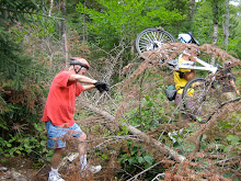
The rail trail is crushed, packed stone and almost 7 miles long. In all we’ll peddle about 15 pretty easy miles on this loop route. From the trailhead at the restored train depot on Railroad Avenue, the crushed stone Russell C. Chase Bridge Falls Path leads to the rail trail proper. After the falls, the trail goes by a beaver pond with great views and bird watching and it also passes through some interesting tornado damage from 2008. Causeways that lead across Crescent Lake, then along Lake Wentworth are another stunning feature on this trail. At times you're surrounded by water on either side, and the views are nothing short of spectacular. And in a unique rail trail twist, sections of the trail actually run between the old rails, which are still in place and visible, though you cannot see the ties.
It ends at the intersection of Cotton Valley Road. Here we’ll go left (west) and return on Cotton Valley Road which becomes College Road. Both roads have gently rolling hills with the exception of one steep, but short hill on the way back. To get back to the rail trail and avoid the busy routes into Wolfeboro we’ll take a left on Westwood Drive to Tennis Court Lane which leads back to the rail trail and the center of Wolfeboro.
After the ride we can explore the shops and points of interest in Wolfeboro, one of the original resort towns on Lake Winnipesauke.
The Wolfeboro trailhead is at the restored train depot on Railroad Avenue, just west of the Route 109 and Route 28 intersection. Parking is available at the depot. Take route 16 south to route 28 (just before Ocean State Job Lot) in Ossipee. Go west about 9 miles on route 28 to Wolfeboro center. Then take a right on route 109 to Railroad Ave.
Please be ready to start the ride at 11:00am.
So you're invited to join in the fun!
Joan
Sunday, December 11, 2011
Monday, November 28, 2011
North Fryeburg Ramble
With snow still on the ground it looks like we'll have to ride on roads that were plowed after last Wednesday's storm. So how about meeting at the North Fryeburg fire station at 10:00am? We'll decide on a route then.
Monday, November 21, 2011
Still Wanna Ride?
Tomorrow's forecast is in the gray zone for bike worthy conditions. Many of the core group will be away for the holiday. So if there are fellow nut cases who still want to ride send me an email and let me know. If I hear from a few of you by this afternoon we'll put something together based on our combined interests. One way or another I'll post something more definitive tonight.
There has been no groundswell of enthusiasm for a ride tomorrow. So let's look forward to better weather next week.
There has been no groundswell of enthusiasm for a ride tomorrow. So let's look forward to better weather next week.
Monday, November 14, 2011
Tour de North Conway
Let's meet at the Scenic Overlook in North Conway. We'll ride through the fields near the Saco on dirt roads, trails and a bit of route 16 to downtown North Conway. Then we'll explore Whitaker Woods before taking a trail along the scenic railroad tracks back to our starting point.
Right now the NWS is forecasting a 30% chance of rain tomorrow so if the weather turns against us we'll never be very far from our cars. Check back Tuesday morning to make sure the ride is still on.
Meet at 10am. See you there.
Right now the NWS is forecasting a 30% chance of rain tomorrow so if the weather turns against us we'll never be very far from our cars. Check back Tuesday morning to make sure the ride is still on.
Meet at 10am. See you there.
Monday, November 7, 2011
Bog Dam Loop
Tomorrow looks like a fabulous day for a ride! And here's another new route to explore! The Bog Dam Ride is a pretty 17 - 18 mile dirt road loop in the WMNF section of Berlin. On Friday the road surface was very smooth and dry too.
Initially the road wends its way along the upper Ammonoosuc and then it rises through the woods with occasional views of the surrounding mountains. The first six miles ascend to the highest point of the ride and while its not quite all downhill from there the hard work is mostly done.
For those of you who haven't ridden with us for a while this is the ride for you. The surface is really smooth and tomorrow is going to be perfect for riding. The leaves are down and we'll be getting plenty of sunshine. For more info on the ride check out Marty Basch's "White Mountain Ride Guide" 2nd edition p83.
If you'd like to carpool meet at The Old Jackson Town Hall at 9:25am We'll start the ride at 10:30an.
Directions - Go north on route 16 to Berlin. Just after the road becomes one way in downtown Berlin go left on route 110. Follow 110 for about 7+ miles to York Pond Road on the left hand side. Go 1.5 miles on York Pond Road to the point where FR 15 forks to the left. Take FR 15 and park up on the right in a large dirt parking lot.
Monday, October 31, 2011
Harmon Notch Loop
Here’s a brand new ride! And it’s a notch ride. What? A fat tire notch ride you say? Yes indeedy! This is a really pretty ride through a notch that most of us have never heard of. Harmon Notch is located between Peary Mountain and Frost Mountain. The best part is that it’s only a 175’ elevation gain and most of the climb is on a good section of dirt road. What a cheap date!
The starting point for this ride is at The Maine Information Center on route 302 in Fryeburg. We’ll head south on Haleytown Road which has been recently repaved and there’s not enough O’s in smooth to do it justice. Then it’s left on Farnsworth, which is a dirt road, and after a mile or so we’ll hop onto a jeep track that crosses the Little Saco and then heads back to Haleytown.
At Hampshire Road we’ll go left and head in the direction of a dirt road called Harmon Notch Road. After the last house this road gets narrower and towards the notch area there is a half mile section that could benefit from better drainage and fewer rocks. Don’t let this “spook” you it’s no harder than other rides we’ve done. And for some of us it will provide an excellent opportunity to walk our bikes. We’ll come out on a different section of Farnsworth Road and head west. Then we’ll head north on Porter Road (dirt) and take the newly constructed Mountain Division Rail Trail in Fryeburg back to our starting point.
Wear bright clothes, it is hunting season. I didn’t see any hunters in this area when I was scouting this ride, but it’s best to be bright this time of year. In all we should cover about 16 – 17 miles. Dress warmly. Expect mud and perhaps a bit of left over snow.
Carpooling – Meet at the scenic overlook in North Conway at 10:20am.
We’ll start the ride at 11am from the Maine info center. Don’t forget to bring a lunch.
Monday, October 24, 2011
Tour de Gorham
Here’s another fun ride for you this Tuesday. This perennial favorite is about a 14 mile circumnavigation of Gorham on mostly dirt roads and trails with a bit of paved road thrown in too. The starting point is at the route 2 parking lot for the Presidential Rail Trail.
We’ll start out on the gravel Gorham Emergency Road which is closed to motorized vehicles except in (you guessed it) emergencies when Route 2 through the center of town is impassable. At the airport we’ll get onto the pipeline trail which will take us by the south side of the airport thus avoiding the roads of downtown Gorham. After about a mile we’ll cross route 16 and take a residential road to a foot bridge across the Peabody River and get back on the pipeline trail. Here there will be a short but very steep hill to walk up with the bikes. And then it's a pretty much of a straight shot on the pipeline trail back to Route 2 and North Road. There is the option to leave the pipeline trail at various points and take Route 2 if the group prefers a smoother paved surface for this segment of the Tour de Gorham.
As we cross over the Androscoggin River we can view the progress to the repairs on the Shelburne Dam which was seriously damaged by Hurricane Irene. Next we’ll follow Hogan Road west for about 5 miles on the virtually untraveled north side of the Androscoggin River where there will be awesome views of the river and several power dams. Then we’ll take a left onto the Presidential Rail Trail which will take us back to our cars. Most of this ride will be on pretty flat and smooth trails and roads. The exception is the pipeline trail which has rolling hills and several excellent opportunities to walk the bikes.
Directions: Go north on Route 16 to Gorham. When route 16 meets route 2 at the T intersection turn left. Go through Gorham on Routes 16 and 2 until Route 2 diverges to the left at the traffic light . You'll see the trail head parking lot on the right about .8 miles after you turned left on Route 2.
For those of you who want to carpool meet at The Old Town Hall in Jackson, across the road from the post office at 9:20.
Let's start the ride at 10:00am.
Sunday, October 9, 2011
Deer Hill and Basin Loops
Tuesday October, 11th
Last year this ride was absolutely spectacular!!! The foliage was magnificent and we had Evans Notch pretty much to ourselves. There was hardly any traffic on route 113. We all agreed this was one of the best rides of 2010.
This route loops around Deer Hill on route 113, Stone House Road, Shell Pond Trail, a bit of Shell Pond Loop Trail and Deer Hill Road. Most of the loop will be on dirt roads or trails. There will be one trail segment that is a bit rough (but quite doable) especially where we will link up to Deer Hill Road from the Shell Pond area. Then we'll make another loop as we head up to the Bricket Place and on to The Basin for a lunch amid the eye popping scenery. And then it's back to our cars via route 113.
We’ll start the ride at the Forest Service parking lot which is about .10 mi north of the AMC Cold River Camp entrances on the right side of route 113. Meet for car pooling at the Scenic Vista parking lot in North Conway, at 9:10. We should be ready to start the ride at about 10:00am.
Sunday, October 2, 2011
Tuesday October 4th
Curses Foiled Again!
All the forecasts point to a soppy day. So there won't be a ride tomorrow. Let's try again next week.
Rain Delay
Oh boy another tough forecast to deal with. This looks like a squeeker. Come back Monday night at the earliest.
I had hoped to do the Shell Pond/ Deer Hill loop and then up to The Basin in the southern part of Evans Notch which is one of the best rides of the year. If anyone has some ideas please let me know.
Sunday, September 25, 2011
Wild River Ride
This Tuesday September 26th, we'll do an out and back ride in the Wild River Valley from Route 2 to the end of Wild River Road. The Wild River Trail beyond the campground experienced serious flooding as a result of Hurricane Irene and we won’t be able to ride past the campground on bikes. But we can walk into this area to see firsthand the devastation of Irene. So we’ll try a new starting point and ride about 3 miles up to Wild River Road on Route 113 from the intersection of Routes 2 and 113.
This ride is in a beautiful area and the foliage will make it gorgeous. We may encounter a few cars on Route 113, but weekday traffic should be light. The dirt Wild River Road is closed to auto traffic so we should have that all to ourselves with the exception of the occasional Forest Service vehicle. As we bike the 6 miles to the campground we’ll get a sense of the force of the flood waters on the surrounding landscape. It’s not all bad news though as the river views from the road have been greatly enhanced. In all we’ll cover something like 18 miles.
Directions: Go to Gorham on route 16 north. At the Route 2 intersection go right toward Maine. About 2 (I think it’s 1.9) miles beyond the Maine State line take a right onto a dirt road which leads to the site of the old bridge and a large parking area. If you get to the new bridge which is just beyond our turn off you’ve gone too far. And if you get to Route 113, on the right, just over the new bridge you’ll know you’ve over shot the starting point.
Let’s start the ride at 10:00am. It’s going to be a beautiful day and we can have a picnic lunch along the river. If anyone wants to carpool meet at the Jackson Old Town Hall parking lot across from the post office at 9am.
Sunday, September 18, 2011
Tuesday September 20th
No Ride Today - Tuesday 9/20
Monday Update 6:30 pm
Check back tomorrow morning around 7:30 to check if the ride is still on. The weather forecasts are all over the place. The probability for precipitation during ride time runs from 30% - 90%. Erg!
If we can get a ride in, this is it.
East Branch River Ride
It would be interesting to ride up Town Hall Road to see all of the hurricane damage done by the river. The part above Glenn and Trish's house is gated off for cars, but not for bikes or walking, so there would be no traffic.
Meet at 9:00 am, ready to ride at the Bartlett Town Hall to bike up Town Hall Road along the East Branch River as far as the weather allows. If the rain comes, it is an easy downhill cruise back to the cars.
Sunday Posting
Hi Everyone,
I'm on The Cape and Marianne has generously agreed to organize this week's ride. The forecast is slightly iffy so Marianne is going to hold off until tomorrow to choose the route. Please check back on Monday for the Tuesday ride plan.
Thanks, Joan
Saturday, September 10, 2011
Rob Brook Road - A Valley Classic
It’s time to do the Rob Brook Road Loop, which is a valley classic. This area has a reputation for being buggy. Two years ago when we rode this route in July it lived up to its reputation. But the bugs have left us for the most part and its time we got out there for a very pleasant ride. This is a rolling 12 mile ride, suitable for all abilities, mostly on a winding dirt forest road with the last few miles on the Kanc and Bear Notch Road. There are hills to climb and they are quite doable.
Marty Basch describes this ride in his White Mountain Ride Guide as follows "The road winds by streams and huge boulders. Spotting signs of moose and deer are common. A few quick climbs are rewarded with refreshing downhills."
The Saco Ranger Station has said that the road is open and passable. Plan on getting your feet wet as we need to cross the Swift River to get to the Kanc. A good lunch spot is at The Russell Colbath House (on The Kanc) where there are picnic benches by the barn. If the river is too high we can just retrace our tracks back to Bear Notch Road which will add about 5 miles to the ride.
The Trail Head and parking are on the west side of Bear Notch Road .75 mi north of the intersection with The Kanc. We will start the ride at 10:00am. So please be there about 9:50am. See you there!
Monday, September 5, 2011
Go With The Flow
The forecast is for 1" to 2" of rain tonight into tomorrow morning. So let's turn lemons into lemonade, make the best of a bad situation, go with the flow, etc, etc...
So here's a really fun idea! After 5pm bikers are allowed to cruise up the closed section of route 302 in Bartlett and Hale's Location. Imagine a major highway with no cars! And some very interesting post Irene scenery. We can go as far north as we we want to and as the day light permits. If you like, pump up your tires as we should be on pavement most of the way.
Let's meet at the pull out/parking on the left before the barricades. These barricades are just past Bear Notch Ski Touring Center on route 302 in Bartlett. Please pull off the road as far as you can so that we don't block turning vehicles.
Meeting time is 4:45.
Check back here around 3:30pm if it's still raining tomorrow afternoon.
Sunday, August 28, 2011
Hurricane Hiatis ???
FYI...
Today, Monday August 29th, the WMNF extended it's closure notice as follows...
"The White Mountain National Forest will remain closed until further notice. Forest Service personnel are currently verifying the conditions and stability of the roads, bridges, campgrounds, trails and other facilities on the Forest. Please be advised that road surfaces may appear stable but could give way under little weight. The Kancamagus Highway is closed."
There will be no ride tomorrow.
Well this is a fine pickle. Tuesday's forecast looks great, but will the trails be passable? A power outage is quite possible so I may not be able to update this blog in a timely manner. If there is no update there is no ride this Tuesday August 30th.
However if the conditions permit, a road ride in North Fryeburg, the old standby, is a possibility. If you have another idea please drop a line or give a jingle.
Stay dry.
Sunday, August 21, 2011
Bretton Woods Downhill Biking
A new and exciting adventure! On Tuesday we will be the Fat Tire Flyers. This will be our first try at lift assisted biking and I can't wait. We'll be taking multiple rides on the Bethlehem Express Quad Chair Lift up Mt Rosebrook to the Top of the Quad Restaurant. From there we can go left to the two miles home trail or we can go right to several trails on West Mountain. For the really adventurous, there are several black diamond trails on Mt Rosebrook. Which ever way we go we will have rollicking, riotous rides downhill.
Bring you lunch or get it at the mountain. The views from the Top of the Quad Restaurant should be spectacular. The forecast is for a wonderful day. There will be plenty of sunshine with puffy clouds and low humidity. So check your brakes, oil your chain and head out to Bretton Woods Tuesday morning. Don't forget your helmet, it is required attire.
Let's meet at 9:30am at the Adventure Center (aka the Base Lodge) by the desk on the main floor. We'll purchase our tickets as a group.
Carpooling: Meet at the back of the Attitash lot at 8:50am
Sunday, August 14, 2011
This Ride is a Blast!
So far we've had about an inch of rain and the forecast is for another inch of rain to fall tonight. The NWS is also predicting a 70% chance of rain tomorrow. So the ride tomorrow is cancelled.
Tuesday August 23rd we are scheduled to go to Bretton Woods for a 1/2 day of lift assisted riding. To get the group rate we need 12 riders. At present we have 10. Please extend an invitation to anyone you might think would enjoy this type of biking.
It's the height of vacation time in Vacation Land. So let's do something really fun. We'll start off at the top of Bear Notch Road and cruise down the dirt roads in the Bartlett Experimental Forest. Then we'll cross over to the east side of Bear Notch Road and do some fun single track and old logging roads on the Reservoir Brook Trail.
Let's meet at 9:30am, in the parking lot off River Road just after it crosses the Saco River in Bartlett.
Directions: Take Route 302 to Bartlett, at the blinking light in the center of Bartlett take a right and in about half a mile you'll cross the Saco River and the parking area will be to the left of the bridge. This will be a lovely lunch spot after our mostly downhill ride.
We will need to shuttle people and bikes up to the top entrance of the Experimental Forest (which is almost at the top of Bear Notch) from the parking area. Then we'll start our mostly downhill adventure.
At present the forecast is a mixed bag. So check back here Tuesday at about 8:00am if the weather looks iffy.
Monday, August 8, 2011
Rocky Branch via Allen and Jericho
Let's ride from The White Mountain Cider Company to the Rocky Branch Shelter #1 via Allen and Jericho roads tomorrow August 9th. This is about a 13 mile ride which retraces most of the lower half of the Rocky Branch Logging Railroad that operated from 1908 to 1914. We'll ride on dirt roads and dirt trails most of the way. Be prepared to get your feet and legs wet when we cross from Allen Street over the river toward Jericho Road. It's a short crossing, but expect to hit a small pocket of water that is knee deep.
On this back woods rail trail there may be stream crossings, trees across the way and waterbars which will necessitate getting off our bikes to maneuver safely. The return ride will be mostly down hill and a lot of fun!
Meet in the back of the parking lot at The White Mountain Cider Company on route 302 in Glen at 9:30. Bring lunch (or buy it at the Cider Co. Deli), and water, etc.
Click here to see the map:
http://www.mapmyride.com/routes/view/20398484
Saturday, July 30, 2011
Kezar Falls Gorge
Tuesday AM Update - Let's Go!
Monday Evening Update: Right now it looks like the morning weather will be good for a ride. However if the conditions don't look good tomorrow morning check back around 7:30am for an update.
It’s the height of the tourist season. Has anyone else noticed the epic backups going into and out of North Conway? So we need to get far from the madding crowds. And there’s nowhere more remote and scenic as the Old Waterford /Five Kezars Roads area out of Lovell, Maine. You’ll be surprised at the remoteness of the second half of the ride.
We'll start out at the Lovell Historical Society and take Old Waterford Road to the Kezar Falls Gorge, which Delorme describes as a unique natural area. Then the route will take us to the Five Kezar Ponds where we’ll take a path around one. Next we’ll retrace our tracks back down Old Waterford Road to a dirt road and head out to the Dan Charles Pond area and then after a series of dirt roads we’ll come out on Fern St which will lead us back to Old Waterford Road and the Historical Society.
There are a few hills, primarily at the beginning of the ride so we’ll get our most aerobic exercise during the cooler part of the day. Otherwise the terrain will be relatively easy to cover. The surface will be pavement, pavement reverting to dirt, dirt and packed sandy soil. We should cover about 17 – 19 miles.
Added Bonus: The Historical Society will be open Tuesday so you can nip in there for a look see at the exhibits after the ride.
Please be ready to ride at 9:30am. Park in the lot which is on the left, just across from the historical society building 1.5 miles past the intersection of routes 93 and 5 in Lovell. To get to Lovell take route 5 north out of Fryeburg, Me.
Carpooling: Meet at the Scenic Overlook in North Conway which is conveniently located across the street from Trails End Ice Cream Shop. Meet Time 8:40am
Weather Note: The weather forecast while I’m writing this is for a sunny day with a high Temp of 79. I’m going to post this ride Saturday as I’ll be computerless for the next couple of days. If the forecast does change significantly please check back on Monday evening for an update.
Sunday, July 24, 2011
Bretton Woods Triangle
Tuesday Morning Update: The webcams in Bretton Woods show rays of sun coming through the clouds and the weather radar looks clear. So let's ride!
It looks like we may be able to get a ride in tomorrow morning. So let's try something we haven't done for almost two years - the trails in the National Forest in the triangle created by Route 302, Mt Clinton Road and the Base Road (for the Cog Railway). The word is that these trails have improved in the last couple of years. Generally speaking there will be a gradual, but quite doable, climb during the first half of the ride and a subsequent down hill ride in the second half. We'll cover about 10 - 12 miles of these woodsy and scenic trails.
Meet at 9am at the Eisenhower Memorial Wayside Park which is on the right side of Route 302 between the AMC Center and the entrance to The Mount Washington Hotel.
Carpooling: 8:30 in the Attitash parking lot.
Weather Note: Check this blog tomorrow morning around 7:45 to confirm that the ride is still on.
Sunday, July 17, 2011
Sawyer River Trail and Loop 7/19/11
The Sawyer River Trail is in a seldom visited and very scenic section of the National Forest between the Swift River off the Kanc and the end of the driven portion of Sawyer River Road in Hart’s Location. We’ll get beautiful mountain views especially while we ride the old railroad bed in the wetlands area between Mount Huntington and Green’s Cliff. As a special treat we will have one of the few available views of The Captain (3540ft), which the AMC Mountain Guide calls “a striking little peak, a miniature Half Dome with sheer cliffs overlooking the Sawyer River Valley”.
This trail has a number of surfaces including gravel road, double track, dirt path and old rail bed. I imagine that we’ll encounter some mud so plan your foot wear accordingly. This “rail trail” isn’t as smooth as many of the others that we have ridden this year because some of the 100 year old ties are still embedded in the dirt and we’ll encounter lots of tree roots as well. Other than the first half mile the grade is gentle. It’s the surface that is rougher than usual.
After the Sawyer River Trail comes out at the Swift river we'll retrace our route back to the Hancock Notch Trail. Then we'll ride this segment for a half mile and connect to Forest Road 86. Portions of the Hancock Notch Trail have roots and rocks and some of us will walk the bikes in these parts. After we cross a stream (50% chance of getting wet feet), we’ll go up a brushy embankment and have a rollicking 1.5 mile downhill romp back to our vehicles. In all we'll cover about 9 to 10 miles.
Directions: Take Route 302 west and about 4 miles past the Bear Notch Road intersection in the “center” of Bartlett take a left onto Sawyer River Road which is a dirt forest road. Go another four miles to the end and park.
Please be ready to ride at 9:00am. See you there.
Monday, July 11, 2011
Judy and Joe's Freedom Ride
Judy and Joe have found a great new adventure for us in the Freedom Town Forest. Here's the ride in their own words.
TROUT POND, FREEDOM, NH
DIRECTIONS:
Drive south on route 16 to Conway and take route 153, passing Crystal Lake Inn. Continue past Purity Springs Resort and take a Right on Bennett Road. Follow this tending right and take the first RIGHT after the BLUE MOON STORE. There will be a sign for Trout Pond and Mary's Mountain. Drive down winding paved road to blue signs. Turn LEFT for Trout Pond, and we'll meet at the parking area and kiosk at 9:15 a.m.
At 9 a.m. we'll be at the first King Pine parking lot on the left to meet with anyone who wants to convoy to the Trout Pond parking area.
Carpooling: Meet at the Scenic Vista in North Conway at 8:20am
THE RIDE
From the kiosk parking lot we'll head out on Jackman Ridge Trail riding through "patch cuts" conducted in 2006. It's the removal of larger trees to encourage aspen/birch sapling growth that provides preferred habitat for a variety of wildlife species. Turning left, we'll take a quick side trip to the interesting, abandoned Freedom Airstrip to see a beaver pond. Returning to Jackman Ridge, We'll ride north to the entrances for Trout pond. We'll ride to the second entrance and enter the Outlet to Trout where we'll have lunch. From there we'll go downhill most of the way to Mary's Mountain kiosk. We'll turn right and take the mostly paved Shawtown Road back to the cars.
Total miles: 7 to 10
Time: 2+ hours
Approximate elevation gain over 3 miles: 300’
The weather forecast looks good for tomorrow morning. However if the conditions change check back here by 7:45am.
Sunday, July 3, 2011
Dam, Dam, Dam, Dam and Dam
Tuesday July 5th we'll ride this favorite route, which runs from the Gorham train depot to the Berlin eastside depot. It has a lot of variety, not to mention about five dams. We'll start off in downtown Gorham by the old train station and ride past the airport and then ride a mile through the backs woods on the emergency access road which is closed to motorized traffic. After this we will be riding on the eastern end of the presidential rail trail to Berlin on the quiet and beautiful eastern bank of the Androscoggin River.
Along with getting great views of the Androscoggin we'll skirt a gravel pit, go over the very high trestle bridge across route 16, bike by the hydroelectric powerhouse and dam on the canal adjacent to the Androscoggin, view the Cascade Flats complex and dam from the seldom seen east side and visit a waterfall, for a lunch stop.
The surface of this pretty flat ride consists of dirt, ballast, gravel and the occasional mud puddle. This 17 mile out and back route is appropriate for all abilities. The ride will start at 9:00 on Railroad Street across from the Gorham Town Common. Please note the earlier start time, it's forecasted to be a hot day.
Carpooling: Meet at the Old Jackson Town Hall, parking lot (across from the post office) at 8:20.
Directions: Drive north on route 16 to Gorham. Just before the T intersection with route 2 there will be railroad tracks. Immediately after crossing the tracks turn left onto Railroad Street. Hook a U turn and park on the other side of the road across from the Common.
To view a map of this ride click below.
http://www.mapmyride.com/routes/view/20611220
Monday, June 27, 2011
New Adventure - Ammonoosuc Rail Trail !!!
Two years ago we rode the northern half of the Ammonoosuc Rail Trail from Littleton to Lisbon and had a great ride on a wonderful rail trail. With a little prompting from the usual suspects (you know who you are) and a forecast for a beautiful day it seems that tomorrow would be the perfect day to complete our exploration on the southern section of this trail. The Ammonoosuc River provides a gorgeous backdrop to this trail. And there is a magnificent 345 foot covered bridge that was built in 1832 in Bath.
The Ammonoosuc Rail Trail from Woodsville to Lisbon wends its way along the Ammonoosuc River by field, farm, quaint villages and some very interesting backyards. In all we’ll cover about 20 miles on this easy and flat dirt track. After getting to Lisbon we’ll turn around and head back to our lunch spot in Bath which is a quintessentially scenic New England Village with a gorgeous covered bridge and a well stocked General Store. And the last time I was in Bath there was an ice cream store and an art gallery too. What’s a better combination than culture and ice cream?
Directions and Carpooling: Meet at 8:30 in the back of the Attitash parking lot. There are several ways to get to Woodsville that take about the same amount of time. There’s (A) 302 to 93 to 302 or (B) Bear Notch road to 112 to 302 or (C) 302 to 93 to 117 to 302. So pick your favorite and meet us at about 10am at the starting point in Woodsville.
When you approach Woodsville there is a stop light at the intersection of routes 302 and 10. Go west toward downtown Woodsville on 302 for about ¾ of a mile. After awhile you will probably see a dirt path paralleling 302 on the right. This is the rail trail. At Highland St go right and then take a quick left on a dirt road/driveway. We will park in the dirt lot just down from the Railway Farm and Garden Store and Central Supply.
Go here for a trail map:
http://www.mapmyride.com/routes/view/11620932
For those who want a little extra riding (6 mi.) you can explore the Blackmount spur to North Haverill from Woodsville at the end of our ride
Sunday, June 19, 2011
Pondicherry - The Lupine Tour
The weather forecast looks great for Tuesday June 21st! Let's do an amazingly scenic ride in the Jefferson area while the lupine are blooming.
We’ll start at the western terminus of The Presidential Range Rail Trail and pedal through almost four miles of The Pondicherry National Wildlife Refuge where the views are absolutely magnificent. Then we’ll head for more open vistas on three miles of paved country road and another three plus miles on the dirt Valley Road. When we reach Jefferson Notch Road we will return to Pondicherry on The Rail Trail. In all we’ll cover about 18 miles with breath taking spring views and lots of gorgeous lupine.
The rail trail has a pretty firm surface and is a combination of dirt, gravel, stone, cinder and ballast. Since the new culverts and bridges were installed more than a year ago, the rail trail has been solid and dry. This is a relatively flat route with no major hills. It’s just a wonderful cruise through a beautiful area.
Bring your cameras; the scenery here creates magazine quality photos!!!
Directions: Take route 302 through Bretton Woods and at the traffic light go right on route 3 for 1.9 miles. Then take another right on route 115. In 4.4 miles Hazen Road will be on your left, take it. In another 1.4 miles you will see a sign on the right saying Presidential Recreation Trail Pondicherry. Go right into the small parking lot. We may have to do some creative parking to fit us all in here.
Carpooling is a must due to the small parking lot at Pondicherry. Meet at 8:55am in the Attitash parking lot. Please be ready to ride at 10:00am.
Click here for a map of this ride.
http://www.mapmyride.com/routes/view/11313897
Sunday, June 12, 2011
June 14, 2011
Update - It's lightening up, let's ride!
Another forecast with a possibility (40%) of rain, ergh. Well let's think positively and plan for a ride tomorrow. How about another close to home ride in case we need to bail out (literally) early?
So let's explore the trails around and near Thorne Pond and the Saco in Bartlett. These fun and virtually flat trails range from logging type roads to single track. While most of the trails are appropriate for an experienced novice, there will, occasionally, be quick turns, roots, stones and mud to ride around or over. There are a couple of spots where getting off the bike may be advisable. There aren't any difficult trails. So we should have a very nice ride. And if it does start to rain we won’t be very far from our cars.
We'll meet in the back of the Attitash parking lot, across route 302 from the mountain. Park in the back of the lot by the parking shack to avoid using spaces that Attitash customers might need. Be ready to ride at 10:00am.
Rain in the morning will cancel the ride. Check back here tomorrow morning around 8:00am to confirm that the ride is still on.
Monday, June 6, 2011
Echo Lake and Cedar Creek Trails
Tomorrow, Tuesday June 7th, let's plan on riding the trails near Echo Lake and the National Forest trails to the west of the Cedar Creek and Birch Hill neighborhoods off West Side Road in North Conway.
Most of the ride is pretty flat and suitable for all abilities. So for those of you who are fairly new to fat tire riding this would be a great ride. We will cover about 4 miles of pavement and 8-10 miles of dirt forest trails. We will cross a couple of brooks, and most of us should keep our feet dry.
We'll meet at 10:00am in the parking lot just outside and to the left of the gates to Echo Lake State Park in North Conway. From there we'll ride south on West Side Road for about 3 miles and then enter The National Forest on a trail in the Cedar Creek Development. After exploring the forest roads and an old rail bed in the Moat Trail system we'll head north back to the trails by Echo Lake for further explorations.
Bug spray is recommended. And bring your lunch. See you there.
Sunday, May 29, 2011
May 31, 2011 Ride
Tuesday's forecast looks fine and it's about time. So how about a fairly easy, well drained and gorgeous route! This will be one of the most beautiful rides of the season!!! There's lots of water and lots of fabulous views. This is a special ride. And we can stop at the Northland Dairy for a yummy after ride treat.
The ride starts across the street from the Berlin Airport. We'll go north on the rural and quiet East Side River Road which closely follows the Androscoggin River and has wonderful views. Next we'll turn right onto Hill Street, a dirt road which gently rises through woods and farm lands and takes us on a loop and back to East Side River Road. From here we'll ride to dirt roads which parallel a hydropower canal before getting us to the seldom visited east side of the Androscoggin River. Before starting our return on East Side River Road we'll stop by the hydro station south of the dam where there is a lovely water front spot for lunch.
To see the map of this 18 mile ride click here: http://www.mapmyride.com/routes/view/17313468
Take route 16 north through Berlin. About 3 miles past the Nansen Wayside Park (old ski jump on the left and waterfront park on right), Bridge Street will be on the right. You should also see an airport sign pointing right too. Cross over the Androscoggin River and at the end of Bridge Street pull into the ball park lot on your left
Carpool: Meet at 9:0oam at The Old Jackson Town Hall which is across the street from the Post Office.
Please be ready to ride at 10:00am Tuesday May 25th. See you there for a very special ride.
Monday, May 23, 2011
Fryeburg Black and Tan
Tuesday Morning Update:
It looks like we'll have a window of bike ride opportunity. Let's Go!
There is a sun up there. I almost saw it yesterday! So let's be positive and plan for a ride tomorrow. We need a route that is well drained and doesn't get us to far away from our cars or other shelter in case it precipitates while we're on our bikes. (Notice I didn't use the "R" word.)
This easy and unbelievably scenic 15 mile ride is part pavement (black) and part dirt (tan), hence the route's name Fryeburg Black and Tan. It starts in the beautiful North Fryeburg farm lands with fabulous mountain views. Then it takes dirt roads along the Old Course of the Saco River to Hemlock Covered Bridge, where there are more farm fields with gorgeous vistas.
We'll meet tomorrow morning, May 24th at 10:00am, ready to ride, at the park next to the Saco Valley Fire Station in North Fryeburg, at the corner of Route 113 and South Chatham Road. Do not park in front of the fire station, park on the side of the road next to the park. Bring lunch, water, sunscreen? and bugspray!.
Carpool - Meet at the Scenic Overlook at 9:15am
It looks like we'll have a window of bike ride opportunity. Let's Go!
There is a sun up there. I almost saw it yesterday! So let's be positive and plan for a ride tomorrow. We need a route that is well drained and doesn't get us to far away from our cars or other shelter in case it precipitates while we're on our bikes. (Notice I didn't use the "R" word.)
This easy and unbelievably scenic 15 mile ride is part pavement (black) and part dirt (tan), hence the route's name Fryeburg Black and Tan. It starts in the beautiful North Fryeburg farm lands with fabulous mountain views. Then it takes dirt roads along the Old Course of the Saco River to Hemlock Covered Bridge, where there are more farm fields with gorgeous vistas.
We'll meet tomorrow morning, May 24th at 10:00am, ready to ride, at the park next to the Saco Valley Fire Station in North Fryeburg, at the corner of Route 113 and South Chatham Road. Do not park in front of the fire station, park on the side of the road next to the park. Bring lunch, water, sunscreen? and bugspray!.
______________________________________
Due to Uncertain Weather Conditions - Check This Blog Tomorrow Morning by 8:15am to Confirm That Tuesday's Ride is a Go!!!
Carpool - Meet at the Scenic Overlook at 9:15am
Click here to view the route map.
http://www.mapmyride.com/routes/view/17157820
Post Ride Adventure Bonus
For those with the inclination and the time we can explore Federal Street where, it is rumored, there is a dirt road that connects MacNeil Street with Route 5. This should add about 5 miles to the ride total.
http://www.mapmyride.com/routes/view/17157820
Post Ride Adventure Bonus
For those with the inclination and the time we can explore Federal Street where, it is rumored, there is a dirt road that connects MacNeil Street with Route 5. This should add about 5 miles to the ride total.
Sunday, May 15, 2011
Tuesday - May 17, 2011 Ride
Sleep late, tomorrow's ride is canceled. All the forecasts include rain. Rats!
-------------------------------------------------
Will we go for a ride on Tuesday?
Or will it be our first blues day?
Check back Monday night
It may be alright
Or it may be another snooze day!
-------------------------------------------------
Will we go for a ride on Tuesday?
Or will it be our first blues day?
Check back Monday night
It may be alright
Or it may be another snooze day!
Sunday, April 10, 2011
First Ride of 2011 Season
A great "starter" ride is the Presidential Range Rail Trail in Gorham. This easy trail, on the old B&M railbed, will take us through the woods with beaver ponds and meadows and some beautiful mountain views, to the height of land at the Castle Trail in Bowman (Randolph). We'll cover about 18 miles while we ride out and back from the trail head on Route 2 in Gorham. The ride back to our starting point will be a breeze as it is ever so slightly downhill.
Directions: Go north on Route 16 to Gorham. When route 16 meets route 2 at the T intersection turn left. Go through Gorham on Routes 16 and 2 until Route 2 diverges to the left at the traffic light . You'll see the trail head parking lot on the right about .8 miles after you turned left on Route 2.
For those of you who want to carpool meet at The Old Town Hall in Jackson, across the road from the post office at 9:15am.
View the map of this ride by going to:
http://www.mapmyride.com/routes/view/18981084
Subscribe to:
Posts (Atom)