Tuesday's ride, October 26th, in The Pine Barrens was great. The weather was sunny and mild, we covered some new territory and had an extremely nice lunch on a warm sandy beach on the shore of Lake Ossipee.
For the month of November, fellow Jacksonite, Bob Houlihan, will be coordinating the rides. As each Tuesday approaches he will be sending out an email to all those who have ridden with us this year, with the ride plan. Many thanks go to Bob.
Who knows how many more rides we have left before we start skiing?
SAVE THE DATE !!! Our end of season party is scheduled for the evening of December 11th. As we get closer to that date you'll receive more details.
Thursday, October 28, 2010
Sunday, October 24, 2010
Tuesday October 26th - The Pine Barrens
Let’s explore the Pine Barrens in Madison. This area is New Hampshire’s last intact example of a pitch pine/scrub oak woodland, a globally rare forest type. The main trails are wide, firm(if a bit sandy) and flat. There may be a section or two of the West Branch Trail that is wet due to the recent rains. So expect a bit of mud and a walk through this area. There will be a couple of trail segments that are more like simple single track than the main wide trails. Also we'll take a new route to Lake Ossipee and Camp Calumet and back which will require an easy "bushwhack" through a sandy area. We should cover about 10 miles in two hours or so. This ride is suitable for a confidant advanced novice. We’ll stop for lunch at Silver Lake.
Directions: Take Route 16 south of Conway to the intersection of Route 113 at Coleman’s. Take a left and follow 113 through Madison. After you see Silver Lake on your left, Route 41 will diverge to the left. Follow Route 41 for 3.4 miles along the western side of the lake. The Nature Conservancy entrance and sign will be on the left directly opposite Black Birch Road. Drive in to the kiosk and parking area.
Or take Route 16 south to the junction of Route 16 and Route 41 in Ossipee, follow Route 41 north for approximately 2 miles, crossing into the Town of Madison. The entrance to the preserve will be on the right side of the road, marked by a TNC sign
We'll start the ride at 10am. Meet at the Scenic Vista in North Conway for carpooling at 9am.
Sweet Success - Post Ride Note
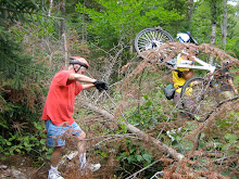
This was another great ride. Fabulous views were abundant all along the ride. After exploring a bit we found a snowmobile trail that completed the loop around Success Pond. To find this loop follow the road on the eastern side of the pond to Black Strap Road and go left. At the second trail to the left after crossing the brook go left. There is a sign here that prohibits ATVs. Follow this trail back towards the pond and when you come to an intersection after a long uphill go left again and descend back to the west side of Success Pond. In all we covered 18 miles and saw a moose.
Sunday, October 17, 2010
Sweet Success
The Rob Brook Road Loop was the planned ride for tomorrow. But with Friday’s deluge and the cool temperatures forecasted for tomorrow, the Swift River crossing would be problematic.
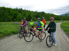
So instead, I'm excited to tell you, we have a special new ride. Last June Marianne biked a very nice section of Success Pond Road and now she wants to take the group on the same ride. This dirt road runs from the east side of Berlin all the way to route 26 in Grafton Notch. But we won't be going that far. Our starting point will be at the Goose Eye Trailhead and we'll pedal into Success Pond for an exploration around the pond and then have lunch. Success Pond Road is mostly flat with occasional brief minor hills. The best part of the road is that it is surprisingly open which will give us fabulous views all along the way. It looks like we will cover about 15 miles on this out and back ride.
Let's meet at 9:45am in the Wentworth Golf Course/Jackson Ski Touring parking lot for carpooling and driving directions. We'll be in the section across from the Jackson Deli. The plan is to start the bike ride at 10:30 on Success Pond Road in Berlin.
Wednesday, October 13, 2010
Deer Hill Loop - Post Ride Note
This ride was absolutely spectacular!!! The foliage was magnificent and we had Evans Notch pretty much to ourselves. There was hardly any traffic on route 113. The interesting dirt road that was mentioned in the previous blog entry proved well worth our exploration and next year it will be the basis for another loop to the north of Deer Hill. This new loop along Bickford Brook Road will include a stop at the Brickett Place, a mini loop off the Royce Trail and lunch at The Basin where the views were just unbelievable. We all agreed this was one of the best rides of the season so far.
http://www.mapmyride.com/ride/united-states/nh/chatham/967128696900873472
http://www.mapmyride.com/ride/united-states/nh/chatham/967128696900873472
Sunday, October 10, 2010
Deer Hill Loop
The weather forecast looks great and the foliage is marvelous. So let’s do The Deer Hill/Shell Pond Loop in North Chatham and Stow, Me that we pioneered last year. You may remember that the views were magnificent especially on the section around Shell Pond.
We’ll loop around Deer Hill on route 113, Stone House Road, Shell Pond Trail, a bit of Shell Pond Loop Trail and Deer Hill Road. Most of the loop will be on dirt roads or trails. There will be one trail segment that is more walkable than rideable especially where we will link up to Deer Hill Road from the Shell Pond area. This 8 mile loop is pretty flat and easy to ride. To lengthen the ride we can choose to do some more exploring (there's one dirt road on our way that looks quite interesting) and/or we can ride up to The Brickett Place on 113 which will add about 3 miles to the ride.
Please, please, please bring your cameras and take pictures.
We’ll start the ride at the Forest Service parking lot (not a fee area in 2010) which is about .10 mi north of the AMC Cold River Camp entrances on the right side of route 113. Meet for car pooling at the Scenic Vista parking lot in North Conway, at 9:10. We should be ready to start the ride at about 10:00am.
Saturday, October 2, 2010
Pondicherry - The Foliage Tour
Don't Miss This Ride!!!
This will be one of the best rides of the year! Pondicherry is unbelievably beautiful and the foliage above the notches is great! This is the ride we wait for all year.
We’ll start at the western terminus of The Presidential Range Rail Trail and pedal through almost four miles of The Pondicherry National Wildlife Refuge where the views are absolutely magnificent. Then we’ll head for more open vistas on three miles of paved country road and another three plus miles on the dirt Valley Road. When we reach Jefferson Notch Road we will return to Pondicherry on The Rail Trail. In all we’ll cover about 18 miles with breath taking fall foliage views.
The rail trail has a pretty firm surface and is a combination of dirt, gravel, stone, cinder and ballast. Since the new culverts were installed late last fall the rail trail has been solid and dry. This is a relatively flat route with no major hills.
Bring your cameras, the scenery here creates magazine quality photos!!!
The drive to and through Crawford Notch is just stunning right now. So take route 302 through Bretton Woods and at the traffic light go right on route 3 for 1.9 miles. Then take another right on route 115. In 4.4 miles Hazen Road will be on your left, take it. In another 1.4 miles you will see a sign on the right saying Presidential Recreation Trail Pondicherry. Go right into the small parking lot. We may have to do some creative parking to fit us all in here.
Carpooling is a must due to the small parking lot at Pondicherry. Meet at 8:55am in the Attitash parking lot. Please be ready to ride at 10:00am
Click here for the route map
http://www.mapmyride.com/route/us/nh/jefferson/246125466746595495
If the weather forecast deteriorates check back here Monday night or Tuesday morning.
Subscribe to:
Posts (Atom)