September 29th Ride
Tomorrow looks like a good day to explore the Rocky Branch Trail in Bartlett. The weather forecasts seem to agree on one thing - Tuesday will start with partly cloudy skies and it will probably rain in the afternoon. So this should be a beautiful morning ride through the colorful woods next to the Rocky Branch of the Saco River.
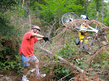
We'll start at the winter parking lot on Jericho Road and pedal about a mile and a half to the end of the driven part of the forest service road. From there we will ride two miles on a gently ascending old rail road bed to the Rocky Branch Shelter #1. Then we have the option of continuing up the trail another three quarters of a mile before turning around at the Wilderness Area boundary where bikes are not permitted. There is a section of the trail here where it appears that the rail bed was washed out and we will have to walk the bikes for awhile going up a steep but short embankment, along the ridge and the back down to the old rail bed.
This rail trail is not as wide or as smooth as others we have ridden and we will cross Lower Stairs Brook on foot, (preferably dry). There are also water ditches and trees across the trail in a few places. These aren't really a problem and can be easily walked or ridden over. When we turn around it will be a fun glide back to the forest service gate. The skill level is advanced novice. We will cover 7.5 - 9 miles depending upon our turn around point.
Directions: Take routes 302 and 16 north to Glen. Stay on route 302 when 16 diverges to the right and in about one mile from the stop light take a right on Jericho Road. The winter parking area will be on your left 2.6 miles down Jericho road. We'll ride out at 10:00am.
If the weather looks sketchy check back here tomorrow morning around 8am for a possible cancelation notice. Otherwise I'll see you at Jericho, Joan
Monday, September 28, 2009
Sunday, September 20, 2009
Tour de Gorham
Tuesday September 22, 2009
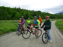
We have another great ride for you this Tuesday. It's about a 12 mile advanced novice circumnavigation of Gorham on mostly dirt roads and double track bike trails with a bit of paved road thrown in too. The starting point is at the eastern end of Hogan Road near the Shelburne Dam.
The group will follow this dirt road west for about 5 miles on the virtually untraveled north side of the Androscoggin River where there will be awesome views of the river and several power dams. A mile or so ride on the presidential Range Rail Trail will connect to the newly built Gorham Emergency Road which is closed to motorized vehicles except in (you guessed it) emergencies when Route 2 through the center of town is impassable. After pedaling through the center of Gorham and past a couple of great restaurants you'll head off to the pipeline trail. Here there will be a short but very steep hill to walk up with the bikes. And then it's a pretty much of a straight shot on the pipeline trail back to Route 2 and North Road where the cars are parked. There is the option to leave the pipeline trail at various points and take Route 2 if the group prefers a smoother paved surface for the final segment of the Tour de Gorham.
Bob Houlihan, who has ridden this route before, will be leading the group on this adventure as I will be on the Cape for a few more days. Thanks very much Bob.
The weather forecast is for decent weather on Tuesday morning. But to be sure, check back here late Monday night or Tuesday morning before 8:15am.
Directions: Drive north on Route 16 over Pinkham Notch, in Gorham take a right on Route 2 east, drive about 3 miles to North Road which is on the left just after a big stone house. Cross the river by the dam and go about 1/4 mile to where North Road bears sharp right. Hogan Road parking area is on the left.
Have fun, Joan
Sunday, September 13, 2009
Echo Lake, North Conway
Tuesday September 15th Ride
It's after Labor Day and the visitors have left. So we will probably have this magnificent area all to ourselves. And Tuesday is forecasted to be a beautiful and sunny late summer day. What could be better?
The route will be a series of four, virtually separate, loops in and around Echo Lake State Park. We'll ride on pretty flat dirt roads, easy and fun single track, woods trails, and a bit of paved road. Along the way we will encounter tree roots, a few stones and a couple of downed trees. Not to worry, these can all simply be ridden over or walked around.
After this ride you will be familiar with most of the trails in Echo Lake State Park. We will probably cover 6 to 7 miles and the pace will be a bit slower than usual given the twisty turny nature of many of the trails here. Hey if I can't get you dizzy I'm sure that you'll get a bit turned around. Lunch will be on the beach with a fabulous view across the lake to White Horse Ledge.
Meet in the parking area to the left, just outside the gates into the Park. Please be ready to ride at 10am.
Monday, September 7, 2009
Sawyer River Trail
Tuesday, September 8th
The Sawyer River Trail will take us through a seldom visited and very scenic section of the National Forest between the Swift River off the Kanc and the end of the driven portion of Sawyer River Road in Hart’s Location. We’ll get beautiful mountain views especially while we ride the old railroad bed in the wetlands area between Mount Huntington and Green’s Cliff. For you rock climbers in the group we will have one of the few available views of The Captain (3540ft), which the AMC Mountain Guide calls “a striking little peak, a miniature Half Dome with sheer cliffs overlooking the Sawyer River Valley”.
This trail has a number of surfaces including gravel road, double track, dirt path and old rail bed. I imagine that we’ll encounter some mud so plan your foot wear accordingly. This “rail trail” isn’t as smooth as many of the others that we have ridden this year because some of the 100 year old ties are still embedded in the dirt and we’ll encounter tree roots as well.
This route is on the easier side of intermediate. Other than the first half mile the grade is gentle. It’s the surface that can be a bit rougher than usual. Since we’ll also have the opportunity to explore a couple of other trails including the Hancock Notch Trail and Forest Road 86 the total mileage will be up to the group and trail conditions. Probably the maximum amount of riding we could do is about 10 miles.
Directions: Take Route 302 west and about 4 miles past the Bear Notch Road intersection in the “center” of Bartlett take a left onto Sawyer River Road which is a dirt forest road. Go another four miles to the end and park. This is a National Forest fee parking lot. You can pay there if you don’t have a permit, bring one dollar bills.
Please be ready to ride at 10:00am. Note the new time, the mornings are getting cooler. See you there.
Subscribe to:
Posts (Atom)