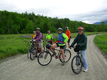
It looks like the season is all over. But don't forget the end of season pot luck party, this Saturday December 11th. See you there!
Happy Trails, Joan
Sunday, December 5, 2010
Monday, November 29, 2010
Last Ride ???
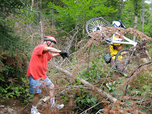
We haven't done the Conway Rec Trail this year. That's a fine kettle of fish! How could that happen? Well let's do it before the snow flies.
The Rec Path saunters along the Saco River and then heads through the woods to The Mineral Springs site where the new high school is located. We will view the Mineral Springs Pagoda and then hop on the path down to route 302 by the old quarry barracks.
Next we'll cross route 302 and enter the trail network leading to the Powerline trail which will take us almost to Puddin Pond before we go west toward the railroad tracks. An old dirt road will bring us back to the quarry area. Here we'll see old structures and machines that the woods are reclaiming. We can explore some of the trails near the quarry or go back down by the Saco to extend the ride and have lunch by the rushing waters.
The main surface will be dirt and there are tree roots in a couple of places. Also we'll ride over one short section of loose gravel by the railroad tracks which our route will parallel briefly.
Meet at the canoe launch parking lot by The Saco River at the end of the road behind the Conway Police Station which is located at the intersection of Route 302 and East Conway Road.
It will be chilly early in the tomorrow morning, Tuesday November 30th, so let's start the ride at 11:oo am. Dress warmly.
Thursday, October 28, 2010
November 2010
Tuesday's ride, October 26th, in The Pine Barrens was great. The weather was sunny and mild, we covered some new territory and had an extremely nice lunch on a warm sandy beach on the shore of Lake Ossipee.
For the month of November, fellow Jacksonite, Bob Houlihan, will be coordinating the rides. As each Tuesday approaches he will be sending out an email to all those who have ridden with us this year, with the ride plan. Many thanks go to Bob.
Who knows how many more rides we have left before we start skiing?
SAVE THE DATE !!! Our end of season party is scheduled for the evening of December 11th. As we get closer to that date you'll receive more details.
Sunday, October 24, 2010
Tuesday October 26th - The Pine Barrens
Let’s explore the Pine Barrens in Madison. This area is New Hampshire’s last intact example of a pitch pine/scrub oak woodland, a globally rare forest type. The main trails are wide, firm(if a bit sandy) and flat. There may be a section or two of the West Branch Trail that is wet due to the recent rains. So expect a bit of mud and a walk through this area. There will be a couple of trail segments that are more like simple single track than the main wide trails. Also we'll take a new route to Lake Ossipee and Camp Calumet and back which will require an easy "bushwhack" through a sandy area. We should cover about 10 miles in two hours or so. This ride is suitable for a confidant advanced novice. We’ll stop for lunch at Silver Lake.
Directions: Take Route 16 south of Conway to the intersection of Route 113 at Coleman’s. Take a left and follow 113 through Madison. After you see Silver Lake on your left, Route 41 will diverge to the left. Follow Route 41 for 3.4 miles along the western side of the lake. The Nature Conservancy entrance and sign will be on the left directly opposite Black Birch Road. Drive in to the kiosk and parking area.
Or take Route 16 south to the junction of Route 16 and Route 41 in Ossipee, follow Route 41 north for approximately 2 miles, crossing into the Town of Madison. The entrance to the preserve will be on the right side of the road, marked by a TNC sign
We'll start the ride at 10am. Meet at the Scenic Vista in North Conway for carpooling at 9am.
Sweet Success - Post Ride Note
This was another great ride. Fabulous views were abundant all along the ride. After exploring a bit we found a snowmobile trail that completed the loop around Success Pond. To find this loop follow the road on the eastern side of the pond to Black Strap Road and go left. At the second trail to the left after crossing the brook go left. There is a sign here that prohibits ATVs. Follow this trail back towards the pond and when you come to an intersection after a long uphill go left again and descend back to the west side of Success Pond. In all we covered 18 miles and saw a moose.
Sunday, October 17, 2010
Sweet Success
The Rob Brook Road Loop was the planned ride for tomorrow. But with Friday’s deluge and the cool temperatures forecasted for tomorrow, the Swift River crossing would be problematic.
So instead, I'm excited to tell you, we have a special new ride. Last June Marianne biked a very nice section of Success Pond Road and now she wants to take the group on the same ride. This dirt road runs from the east side of Berlin all the way to route 26 in Grafton Notch. But we won't be going that far. Our starting point will be at the Goose Eye Trailhead and we'll pedal into Success Pond for an exploration around the pond and then have lunch. Success Pond Road is mostly flat with occasional brief minor hills. The best part of the road is that it is surprisingly open which will give us fabulous views all along the way. It looks like we will cover about 15 miles on this out and back ride.
Let's meet at 9:45am in the Wentworth Golf Course/Jackson Ski Touring parking lot for carpooling and driving directions. We'll be in the section across from the Jackson Deli. The plan is to start the bike ride at 10:30 on Success Pond Road in Berlin.
Wednesday, October 13, 2010
Deer Hill Loop - Post Ride Note
This ride was absolutely spectacular!!! The foliage was magnificent and we had Evans Notch pretty much to ourselves. There was hardly any traffic on route 113. The interesting dirt road that was mentioned in the previous blog entry proved well worth our exploration and next year it will be the basis for another loop to the north of Deer Hill. This new loop along Bickford Brook Road will include a stop at the Brickett Place, a mini loop off the Royce Trail and lunch at The Basin where the views were just unbelievable. We all agreed this was one of the best rides of the season so far.
http://www.mapmyride.com/ride/united-states/nh/chatham/967128696900873472
http://www.mapmyride.com/ride/united-states/nh/chatham/967128696900873472
Sunday, October 10, 2010
Deer Hill Loop
The weather forecast looks great and the foliage is marvelous. So let’s do The Deer Hill/Shell Pond Loop in North Chatham and Stow, Me that we pioneered last year. You may remember that the views were magnificent especially on the section around Shell Pond.
We’ll loop around Deer Hill on route 113, Stone House Road, Shell Pond Trail, a bit of Shell Pond Loop Trail and Deer Hill Road. Most of the loop will be on dirt roads or trails. There will be one trail segment that is more walkable than rideable especially where we will link up to Deer Hill Road from the Shell Pond area. This 8 mile loop is pretty flat and easy to ride. To lengthen the ride we can choose to do some more exploring (there's one dirt road on our way that looks quite interesting) and/or we can ride up to The Brickett Place on 113 which will add about 3 miles to the ride.
Please, please, please bring your cameras and take pictures.
We’ll start the ride at the Forest Service parking lot (not a fee area in 2010) which is about .10 mi north of the AMC Cold River Camp entrances on the right side of route 113. Meet for car pooling at the Scenic Vista parking lot in North Conway, at 9:10. We should be ready to start the ride at about 10:00am.
Saturday, October 2, 2010
Pondicherry - The Foliage Tour
Don't Miss This Ride!!!
This will be one of the best rides of the year! Pondicherry is unbelievably beautiful and the foliage above the notches is great! This is the ride we wait for all year.
We’ll start at the western terminus of The Presidential Range Rail Trail and pedal through almost four miles of The Pondicherry National Wildlife Refuge where the views are absolutely magnificent. Then we’ll head for more open vistas on three miles of paved country road and another three plus miles on the dirt Valley Road. When we reach Jefferson Notch Road we will return to Pondicherry on The Rail Trail. In all we’ll cover about 18 miles with breath taking fall foliage views.
The rail trail has a pretty firm surface and is a combination of dirt, gravel, stone, cinder and ballast. Since the new culverts were installed late last fall the rail trail has been solid and dry. This is a relatively flat route with no major hills.
Bring your cameras, the scenery here creates magazine quality photos!!!
The drive to and through Crawford Notch is just stunning right now. So take route 302 through Bretton Woods and at the traffic light go right on route 3 for 1.9 miles. Then take another right on route 115. In 4.4 miles Hazen Road will be on your left, take it. In another 1.4 miles you will see a sign on the right saying Presidential Recreation Trail Pondicherry. Go right into the small parking lot. We may have to do some creative parking to fit us all in here.
Carpooling is a must due to the small parking lot at Pondicherry. Meet at 8:55am in the Attitash parking lot. Please be ready to ride at 10:00am
Click here for the route map
http://www.mapmyride.com/route/us/nh/jefferson/246125466746595495
If the weather forecast deteriorates check back here Monday night or Tuesday morning.
Monday, September 27, 2010
Tuesday, September 28, 2010
All the forecasts indicate that it will be wet and sloppy tomorrow. So sleep in late and enjoy the extra snooze time.
Sunday, September 19, 2010
Tuesday, September 21, 2010
It looks like virtually all the gang is away or otherwise engaged this Tuesday. I was planning on posting the Rob Brook Road Loop. If there is anyone who wants to ride on Tuesday please email me at chumley@earthlink.net and I will post the description of this loop.
Happy Trails, Joan
Happy Trails, Joan
Sunday, September 12, 2010
Explorer's Club
It's damp but doable, let's go!
It looks like we'll have a small group Tuesday as several members of the gang won't be able to join us. So let's do something that we couldn't do with a big turn out. How about exploring an area that's close to home? There are some trails near the Scenic Vista in North Conway. And there's only one way to find out where they go.
Please meet at the southern end of the scenic vista parking lot at 9:30am Tuesday.
Check back here Tuesday morning at 8am if the weather looks sketchy.
Sunday, September 5, 2010
Sawyer River Trail and Loop
The Sawyer River Trail is in a seldom visited and very scenic section of the National Forest between the Swift River off the Kanc and the end of the driven portion of Sawyer River Road in Hart’s Location. We’ll get beautiful mountain views especially while we ride the old railroad bed in the wetlands area between Mount Huntington and Green’s Cliff. As a special treat we will have one of the few available views of The Captain (3540ft), which the AMC Mountain Guide calls “a striking little peak, a miniature Half Dome with sheer cliffs overlooking the Sawyer River Valley”.
This trail has a number of surfaces including gravel road, double track, dirt path and old rail bed. I imagine that we’ll encounter some mud so plan your foot wear accordingly. This “rail trail” isn’t as smooth as many of the others that we have ridden this year because some of the 100 year old ties are still embedded in the dirt and we’ll encounter lots of tree roots as well. Other than the first half mile the grade is gentle. It’s the surface that is rougher than usual.
After the Sawyer River Trail comes out at the Swift river we'll retrace our route back to the Hancock Notch Trail. Then we'll ride this segment for a half mile and connect to Forest Road 86. Portions of the Hancock Notch Trail have roots and rocks and some of us will walk the bikes in these parts. After we cross a stream and go up a brushy embankment we will have a rollocking 1.5 mile downhill romp back to our vehicles. In all we'll cover about 9 to 10 miles.
Directions: Take Route 302 west and about 4 miles past the Bear Notch Road intersection in the “center” of Bartlett take a left onto Sawyer River Road which is a dirt forest road. Go another four miles to the end and park. This is a National Forest fee parking lot. You can pay there if you don’t have a permit, bring one dollar bills.
Please be ready to ride at 9:30am. See you there.
Thursday, August 26, 2010
Missisquoi Valley Rail Trail
You are cordially invited to join us in an exploration of the Missisquoi Valley Rail Trail in northwestern Vermont. This crushed stone trail runs for 26 miles between St Albans and Richford. It wanders through the farms, forests, fields, and wetlands of Franklin County on steady grades with sweeping bends and postcard perfect landscapes.
We'll be car camping at the Lake Carmi State Park for several nights, which is located a few miles from the mid point of the trail. So each day, for a couple of days, we will ride out and back on about half of the trail.
The State camp ground closes after Labor Day. So we are planning to start this adventure on Sunday August 29th and conclude it by Friday September 3rd. On Tuesday and Wednesday we will actually ride the Missisiquoi Trail. The other days are open for road biking, playing on the lake and just doing the tourist thing.
Please join us!!! The more the merrier!!! Not into camping? There are several inns and B&Bs just off the trail.
If you are interested please let me know which days are available for you between 8/29 and 9/3. I have reserved a lake front lean-to for Sunday to Wednesday nights. More lean-tos should still be available and there are plenty of campsites open.
Here's a short description of the route.
St. Albans to Sheldon Junction
Open, quiet farmland from St. Albans to Green’s Corners. Beautiful wetlands and pines with some residential areas from Green’s Corners to Sheldon Springs. Few road crossings, mostly of gravel roads.
Sheldon Junction to Enosburg Falls
The trail parallels the Missisquoi River offering scenic views of river rapids, quiet pools, working farms, and Jay Peak. Look for fox, deer, and other wildlife. Three crossings of VT 105.
Enosburg Falls to Richford
The trail parallels the Missisquoi River with outstanding views. The landscape offers a nice mix of sunny farmland, shaded forests, and quiet wetlands. Good segment for bird watchers. Multiple crossings of VT 105.
Please thank our local business owners for their generosity in providing restrooms, water, and other services that benefit trail users!
Click below for the trail map.
http://mvrailtrail.com/docs/MVRT-Map-Only-Lo-Res.pdf
Sunday, August 22, 2010
Wild River Ride
This Tuesday August 24th, we'll ride in the Wild River Valley which is a beautiful place to escape the crowds of August. The route will take us along the lovely Wild River on the tree covered Wild River Road. This is a smooth dirt Forest Service Road which follows the river upstream for 6 to 7 miles to the Wild River Campground and a bit beyond. Then it enters The Wild River Wilderness Area where bikes are not allowed. We may encounter a few cars on this road, but weekday traffic should be light. After checking out the pedestrian suspension bridge past the campground, we'll turn around and head back. Only then will we notice, as we fly back, that the road isn't as flat as it seemed when we we're riding upstream.
When we return to the parking lot there will also be an opportunity to visit the other pedestrian suspension bridge over the river and explore the other side on foot or with bikes. And we can go over to the Hastings Campground to find the Gary Moody special spot http://www.pressherald.com/archive/pittston-man-charged-with-climbing-in-toilet_2009-08-31.html .
Meet in the Forest Service parking lot at the intersection of route 113 and Wild River Road. This is a fee parking lot. If you don't have an annual permit bring a few $1's with you for a one day permit. Be ready to ride out at 9:30am.
Please don't forget bring your cameras!
Directions: Go to Gorham on route 16 north. At the route 2 intersection go right toward Maine. When you get to route 113 go right and drive about 3 miles to the intersection of Wild River Road. Go right again and you'll see the parking lot. For some of you it may be more convenient to pick up route 113 in Fryeburg and take it to our starting point. If anyone wants to carpool meet at the Jackson Old Town Hall parking lot across from the post office at 8:20am.
The forecast for Tuesday is a bit iffy (what's new) so be sure to check this blog at 8:00am if the conditions look sketchy.
Here's a map of the ride.
Sunday, August 15, 2010
Experimental Forest Fun Ride
It's the height of vacation time in Vacation Land. So let's do something really fun. We'll star off at the top of Bear Notch Road and cruise down the dirt roads in the Bartlett Experimental Forest. Then we'll cross over to the east side of Bear Notch Road and do some fun single track and old logging roads on the Reservoir Brook Trail.
Let's meet at 9:30am, in the parking lot off River Road just after it crosses the Saco River in Bartlett. Directions: Take Route 302 to Bartlett, at the blinking light in the center of Bartlett take a right and in about half a mile you'll cross the Saco River and the parking area will be to the left of the bridge. This will be a lovely lunch spot after our mostly downhill ride.
We will need to shuttle people and bikes up to the top entrance of the Experimental Forest (which is almost at the top of Bear Notch) from the parking area. Then we'll start our mostly downhill adventure.
Please bring your cameras! We need more people taking photos!! Thanks!!!
Check back here Tuesday at 8:00am if the weather looks iffy.
Sunday, August 8, 2010
Dam, Dam, Dam and Dam
This favorite ride has a lot of variety, not to mention four or five dams. We'll start off in downtown Gorham by the old train station and ride past the airport and then ride a mile through the backs woods on the emergency access road which is closed to motorized traffic. After this we will be riding on the eastern end of the presidential rail trail to Berlin on the quiet and beautiful eastern bank of the Androscoggin River.
Along with getting great views of the Androscoggin we'll skirt a gravel pit, go over the very high trestle bridge across route 16, bike by the hydroelectric powerhouse and dam on the canal adjacent to the Androscoggin, view the Cascade Flats complex and dam from the seldom seen east side and visit a waterfall, for a lunch stop.
The surface of this pretty flat ride consists of dirt, ballast, gravel and the occasional mud puddle. This 17 mile out and back route is appropriate for all abilities. The ride will start at 9:30 on Railroad Street across from the Gorham Town Common.
Directions: Drive north on route 16 to Gorham. Just before the T intersection with route 2 there will be railroad tracks. Immediately after crossing the tracks turn left onto Railroad Street. Hook a U turn and park on the other side of the road across from the Common.
To view a map of this ride click below.
http://www.mapmyride.com/ride/united-states/nh/-gorham/berlin/275128041664486145
Sunday, August 1, 2010
Tuesday August 3rd - TBD
It's raining Boo, Hiss!!! And the radar shows more showers coming at us this morning. Today's ride is cancelled. We'll try again next week.
The weather forecast is problematic, ambiguous, equivocal, indefinite, indeterminate, iffy and not helpful. We may be able to ride in the morning.
Well it's still too close to call. Check back tomorrow morning around 7:30am.
Here's what I'm thinking. If the weather cooperates we can do a favorite ride of mine which starts in Gorham and is 16 miles long. It goes by the airport onto the emergency access road and then onto the rail trail which follows the east bank of the Androscoggin River to Berlin.
If the forecast is still iffy but it isn't raining in the morning we can explore the trails by the Saco across the street from Attitash and Bear Peak.
If it's raining in the morning just pull the covers over your head and go back to sleep (after you check this blog, of course).
If we ride we'll start at 9:30 on either of the routes.
Sunday, July 25, 2010
Rocky Branch via Allen and Jericho
Let's ride from The White Mountain Cider Company to the Rocky Branch Shelter #1 via Allen and Jericho roads. This is about a 13 mile ride which retraces most of the lower half of the Rocky Branch Logging Railroad that operated from 1908 to 1914. We'll ride on dirt roads and dirt trails most of the way. Be prepared to get your feet and legs wet when we cross from Allen Street over the river toward Jericho Road. It's a short crossing, but expect to hit a small pocket of water that is a foot and a half deep.
This is not your usual (relatively smooth) rail trail. There will be rough patches, trees across the way and waterbars which may necessitate getting off our bikes to maneuver safely. The return ride will be mostly down hill and a lot of fun.
Meet in the back of the parking lot at The White Mountain Cider Company on route 302 in Glen at 9:30. Bring lunch (or buy it at the Cider Co. Deli), sunscreen and water.
Click below for a map of the ride:
http://www.mapmyride.com/route/us/nh/bartlett/glen/723128007526281484
Monday, July 19, 2010
Scenic Ammonoosuc
The Ammonoosuc Rail Trail from Littleton to Lisbon was one of the favorite rides we did last year. It is a multi-use rail trail that runs about 20 miles between Woodsville and Littleton along the Ammonoosuc River. Tomorrow July 20th we'll ride on half of the trail from Littleton to Lisbon for about 22 miles out and back, on this almost flat route which wends its way through bucolic woods and farm lands by the Ammonoosuc River. We’ll save the other half of the ride for a later date this year. There may be some ATV or dirt bike riders that will be on the trail with us, although I don't expect there will be many of these vehicles on a week day. If you are so inclined you can cool off in the Ammonoosuc after the ride at the very scenic swimming hole next to the lot where we’ll park our cars.
Littleton is a neat little town. After we ride we can visit Bishops Homemade Ice Cream Shop. Yankee Magazine rated it one of the top five ice cream stands in New England. Need I say more? Also there's Chuttters which boasts the "world’s longest candy counter". Even if you’re not a big candy fan it is quite a sight and worth a visit. Other historic points of interest include Thayers Inn which was built in 1850. Common areas and a couple of rooms are open for viewing. Five Presidents and countless celebrities and national politicians have been guests at Thayers Inn. And there's the Littleton Grist Mill which is a restored 1798 working mill and museum. All of these attractions are in the bustling downtown area and are a short walk from our cars which will be parked behind the Littleton Bike shop in their parking lot.
Bring: plenty of water, sunscreen, and lunch
Directions: Take route 302 northwest to Bethlehem and get on route 93 northbound. At exit 41 head north on route 302 towards downtown Littleton. In about ¾ of a mile The Littleton Bike Shop will be on the left. It is 23 Cottage Street (route 302). Take the driveway/road just before the bike shop building and park in back.
Carpooling: Meet in the Attitash parking lot at 8:15.
To view a map of the whole trail click here: http://www.mapmyride.com/ride/united-states/nh/littleton/431124924892788898:
Be ready to ride at 9:30 in Littleton
Sunday, July 11, 2010
Great Glen Trails
Let's go up to Pinkham Notch on Route 16 to try something completely different at Great Glen Trails. On Tuesday July 13th we'll meet in the parking lot near the front entrance at 9:30am, then buy our day passes and go to the bike shop to develop a group ride plan. The listed daily fee is $8, but if everyone who has a Kiwanis Coupon Book can bring the 2 for 1 Great Glen Trails coupon, we should be able to get everyone in for $4.
There are many types of trails to choose from. We'll explore the easy and intermediate paths and carriage roads as well as some single track and perhaps the pump track before our picnic lunch at a suitably scenic spot. There is a cafe and you can buy your lunch or you can brown bag it. I suspect that we'll all visit the cafe for an after ride "treat". Also for those who want to explore more trails your day pass will be good until 3:30.
Directions: Go north on route 16 to Pinkham Notch. Since this is almost a "local" ride we will not have a carpooling rendez vous spot.
If you have a coupon book please remember to bring it!
If the weather forecast deteriorates please check back here at 8am Tuesday morning.
Sunday, July 4, 2010
Warren Rail Trail Blast Off!
Last fall I discovered (for myself) a really nice new rail trail in Warren, NH. Its going to be hot and humid tomorrow so this shady, woodsy ride will fit the bill. But don't take my word for it see the trail description from Traiklink.com below.
This popular trail starts from an interesting landmark: a Redstone missile brought to Warren by a resident who served in the Army in Alabama in 1970. He found some obsolete missiles in a field and arranged with the Army to transport one back to Warren, aiming to bring something of America's thriving (and far-removed) space program closer to local youth. Placed in the town center in 1971, it remains a prominent fixture.
The rail-trail (a.k.a. the Jesse E. Bushaw Memorial Trail or New Hampshire Snowmobile Corridor No. 5) is a pleasant and picturesque 9.4-mile multipurpose route. The hard-packed dirt surface is generally wide, smooth, and flat, and motorized use is permitted, making it popular among ATV riders in summer and snowmobilers in winter. The trail also welcomes walkers, bikers, equestrians, and anglers eager to try their luck in trailside brooks and ponds.
While most of the route is straight with few technical obstacles, between miles 6 and 7, the trail dips and climbs steeply as it diverges from the railbed to follow State Route 25. Where it rejoins the corridor, the route again runs straight and flat.
Around mile 8, just after you pass the concrete cubes protecting this section of the trail from motorized use, you'll enter the Oliverian Valley Wildlife Preserve's Habitat Management Demonstration Area. Viewing platforms on either side of the path help you keep an eye out for birds and other wildlife.
In the final mile, the trail passes under power lines, swings to the right, and crosses a brook. You'll emerge on State Route 25 in East Haverhill between the Oliverian Valley Campground and a baseball field. This trailhead is difficult to find, so begin your journey in Warren.
Last fall, on this 19 mile roundtrip ride, we past a few walkers and bikers on the Warren end of the path but otherwise Chumley and I had it all to ourselves with no motorized traffic.
Directions: Take the Kanc (route 112) to North Woodstock go across route 3 and continue on route 112 for 2.6 miles. Take a left onto route 118 which will take you to Warren. Look for the upright missile in downtown Warren and we'll figure out parking from there.
Carpooling: For those people who will use Bear Notch Road meet at the Attitash parking lot at 8:00 am. Please email me at chumley@earthlink.net if you plan to start over the Kanc in Conway and you want to carpool.
We should be ready to start the ride at 9:30am.
Map link:http://www.mapmyride.com/ride/united-states/nh/-warren/897125621736444678
Bring plenty of water, lunch and bug spray.
Monday, June 28, 2010
Take a Ride on the B&M Railroad
Three weeks ago we rode on the western half of the Presidential Range Rail Trail. So this week let's explore the eastern half of the rail trail on the abandoned B&M rail bed. We'll cover about 18 miles while we ride out and back from the trail head on Route 2 in Gorham. This easy trail will take us through the woods with beaver ponds and meadows and some beautiful mountain views, to the height of land at the Castle Trail in Bowman (Randolph).
Directions: Go north on Route 16 to Gorham. When route 16 meets route 2 at the T intersection turn left. Go through Gorham on Routes 16 and 2 until Route 2 diverges to the left at the traffic light . You'll see the trail head parking lot on the right about .8 miles after you turned left on Route 2.
For those of you who want to carpool meet at The Old Town Hall in Jackson, across the road from the post office at 9:15am.
View the map of this ride by clicking here: http://www.mapmyride.com/edit_route?r=861127764586893663
Check back tomorrow morning at 8am to confirm that the weather will favor a pleasant ride tomorrow.
Saturday, June 19, 2010
Cedar Creek Loop De Loo
Let's plan on riding the National Forest Trails to the west of the Cedar Creek and Birch Hill neighborhoods off West Side Road in North Conway on Tuesday June 22nd. There are two "loops" which combine about 8 miles of mostly forest roads and about 4 miles of pavement. The total time to do both loops at a moderate pace, is a couple of hours
Most of the ride is pretty flat and suitable for all abilities. So for those of you who are fairly new to fat tire riding this would be the perfect "starter" ride. We will cross a couple of brooks, and most of us should keep our feet dry. Lunch will be at the old quarry where there are great views and there should be a breeze to keep the bugs in check.
We'll meet at 9:30am in the parking lot just outside and to the left of the gates to Echo Lake State Park in North Conway. From there we'll ride south on West Side Road for about 3 miles and then enter The National Forest on a trail in the Cedar Creek Development. Bug spray is recommended.
Monday, June 14, 2010
Pond of Safety Adventure
Join Marianne as she leads the group on a discovery adventure to a new and historical area, the Pond of Safety in Jefferson. Expect the unexpected; "walkable hills", fabulous views, rough patches, wildlife sightings, downed trees or other obstacles, plus the collective thrill of finding a new ride together. Bring lunch, bug dope, water and a sense of adventure. While the group will determine the exact route this map will give you a sense of the possible route. http://www.mapmyride.com/route/us/nh/jefferson/155127651369552241
Below is Marianne's write up.
Meet at the corner of Valley Road and Route 115 in Jefferson at 10:00 am. Drive there via route 302; turn right at the lights onto route 3 in Twin Mountain, then after about 1 mile turn right again onto Route 115. Climb up 115, and eventually the views open up, and there is a scenic vista on the left. Valley Road is about 4 miles after the scenic vista, on the right side of Route 115. It is about 1 mile after route 115A turns left to head towards the Waumbec Golf Club. Turn right onto Valley Road and park off the road in the dirt shoulder near the intersection. We will meet here and proceed either by car to the trailhead or ride our bikes.
The Pond of Safety is reached by about a 3 mile ride on a dirt road that is slightly uphill all the way. The road begins off of Route 2 near Six Gun City. On the way back we can stop for snacks at the Israel River Campground, and if anyone has not seen the lupines on Valley Road, we can do that, too.
Carpool: Meet at the Attitash parking lot at 9:15.
There is an interesting history of this pond:
The info below is copied from: http://www.randolphmountainclub.org/multimedia/publications/foursoldiers/foursoldiers2.html
The Legend of the Four Soldiers
The Name “Four Soldiers” comes from the days of the American Revolution. It is said that four Continental Army soldiers,William Danforth, Benjamin Hicks, Lazarus Holmes, and Capt. James Ryder, were captured by the British and then released under the condition that they would fight against them no more.
For fear of being arrested if they refused combat upon return, the four soldiers escaped and fled home to the North Country, finding their way to the remote pond, where they lived in safety for more than three years, until the war ended. At the war’s end, the four soldiers were exonerated of their charges of desertion and welcomed back to civilization.
From one generation to the next this legend is passed along. Randolph Paths, Randolph Old and New, other mountain guidebooks, and writings about Randolph and Coos County include versions of this tale of the Four Soldiers at Pond of Safety.
Sunday, June 6, 2010
Pondicherry - The Lupine Tour
The weather forecast looks great for Tuesday! Let's do an amazingly scenic ride in the Randolph-Jefferson valley area. The route follows the Presidential Rail Trail into The Pondicherry National Wildlife refuge for most of the way. We will ride the rail trail for 2 miles and then cut over to Valley Road which is a smooth, scenic dirt road. The lupines are blooming in the fields and they will make the rural country views absolutely beautiful. After 3 miles on Valley Road, we will reunite with the rail trail again at its intersection with route 115 and follow it 4.5 miles into the Pondicherry Wildlife National Refuge. This area has great scenery and panoramic views of the Presidentials and magazine-worthy photographic opportunities. On the return, we can retrace our route or ride some pavement on Israel's River Road as a change of venue for awhile. Total Mileage out and back is about 18.5 flat miles.
Start time: 10:00 am, ready to bike.
The ride will start at the Bowman parking area (hikers parking for the Castle trail) on the left (south) side of Route 2. From the Conway area, drive north over Pinkham Notch on route 16. Take a left onto Route 2, drive through downtown Gorham then take a left again on Route 2 as it heads west towards Randolph. Drive about 8.4 miles to the Castle Trail parking area, on the left. It is about 3 miles west of the Appalachia trail head parking area. Bring water, lunch, camera and bug defense.
To view the route, click this link:
http://www.mapmyride.com/ride/united-states/nh/randolph/275124485600141373
For those heading to the Bowman parking area and wishing to carpool, meet at the Jackson XC/Wentworth GC parking lot directly across from the J-Town Deli at 8:55am.
Need more miles after looking out the window at the rain? Marianne is contemplating a ride extension. Does anyone want to join her and start from the east end of the Pinkham B Road? This will add 18 miles to the day, and it includes a climb on Pinkham B and a ride on Durand Road, which is parallel to and north of Route 2. Durand Road ends about 1/2 mile before the Bowman trail parking area. Meet the rest of the riders at Bowman ready to ride at 10:00 after this "warm-up". Call or email Marianne if you want to do these extra 18 miles: 383-9232 or marianneborowski@yahoo.com.
Monday, May 31, 2010
Iffy Forecast for June 1st
Cancelled - The National Weather Service radar shows that the forecasted precipitation is at our door step.
Let's be optimistic, just in case we get a window of opportunity. We'll plan on riding the National Forest Trails to the west of the Cedar Creek and Birch Hill neighborhoods off West Side Road in North Conway. There are two "loops" which combine about 8 miles of mostly forest roads and about 3 miles of pavement. The total time to do both loops at a moderate pace, is a couple of hours
Most of the ride is pretty flat and suitable for all abilities. We will cross a couple of brooks, but most of us will keep our feet dry.
We'll meet at 9:30am in the parking lot just outside and to the left of the gates to Echo Lake State Park in North Conway. From there we'll ride south on West Side Road for about 3 miles and then enter The National Forest on a trail in the Cedar Creek Development. Bug spray is recommended.
Check this blog at 8am tomorrow, Tuesday, morning to confirm that the ride is still on.
Thursday, May 20, 2010
Dam and Dummer
Monday Update:
I've had several inquiries about carpooling for tomorrow's ride. We'll meet at 8:50am at The Old Jackson Town Hall which is across the street from the Post Office and School.
Don't miss this ride!
It will be one of the top three rides of the season!!! Along the way there will be plenty of oohs and aahs accompanied by a couple of wows. There's lots of water and lots of fabulous views. In fact I guarantee a minimum of one eye popping moment per person.
The ride starts across the street from the Berlin Airport. We'll go north on the rural and quiet East Side River Road which closely follows the Androscoggin River and has wonderful views. Next we'll turn right onto Hill Street a dirt road, which gently rises through woods and farm lands and takes us around the Dummer Loop and back to East Side River Road. From here we'll head to The Pontook Dam on neat dirt roads which parallel a hydropower canal before getting us to the seldom seen east side of the Pontook Dam and reservoirs. Before starting our return on East Side River Road we'll stop by the hydro station south of the dam where there is a lovely water front spot for lunch.
To see the map of this 18 mile ride click here:
http://www.mapmyride.com/ride/united-states/nh/-milan/478127439602389259
Take route 16 north through Berlin. About 3 miles past Nansen Wayside Park (old ski jump on the left and waterfront park on right), Bridge Street will be on the right. You should also see an airport sign pointing right too. Cross over the Androscoggin River and at the end of Bridge Street pull into the ball park lot on your left.
Please be ready to ride at 10:00am Tuesday May 25th. See you there for a very special ride.
Monday, May 17, 2010
FRYEBURG BLACK AND TAN
What could be more beautiful than a bike ride among the farm lands and river beds of Fryeburg on a sunny spring day? This easy and virtually flat 15 mile ride is part pavement (black) and part dirt (tan), hence the route's name Fryeburg Black and Tan. Click here to view the route map.
http://www.mapmyride.com/route/us/me/fryeburg/190127409972981564#success
After a few miles of riding by the fields of North Fryeburg we'll head to The Hemlock Covered Bridge on River Road and then Frog Alley. On the way back to North Fryeburg there will be the option to ride off road for about a mile on a trail that parallels Frog Alley.
We'll meet tomorrow morning, May 18th at 10:00am, ready to ride, at the park next to the Saco Valley Fire Station in North Fryeburg, at the corner of Route 113 and South Chatham Road. Do not park in front of the fire station, park on the side of the road next to the park. Bring lunch, water, sunscreen and bugspray. On Sunday there weren't many bugs, but there was a breeze which may have grounded the little buggers.
Sunday, May 9, 2010
A New Season
The weather forecast for Tuesday is great. It is supposed to be sunny with light winds and in the upper 50’s, which sounds like great cruising conditions. Let’s try something we didn't get to last year, Lincoln Woods. It’s perfect for a season opener as it’s easy and quite scenic. Also it is a very highly traveled trail in the summer and fall, but we’ll have it virtually to ourselves at this time of year.
First we’ll cruise out on the East Side Trail, which parallels the eastern shore of the Pemigewasset River, through the woods for 3 miles until we reach the Wilderness Area where bikes are not permitted. Then we’ll retrace our route back and take the Lincoln Woods Trail for 3 miles which follows the western shore of the Pemigewasset River and has great river vistas. After a picnic lunch we’ll retrace our route again back to the Lincoln Woods parking lot.
The East Side Trail is a forest service road and it follows the contours of the woods, so there are short hills along the way. There may be some spots where the gravel is a bit loose. The Lincoln Woods Trail follows an old railroad bed so it is quite flat. There are ties still embedded in the path but they are easily avoided. So keep your eyes on those ties! Mud, as always, is a distinct possibility so plan you foot wear accordingly.
In all we’ll cover about 12 miles. Those who want a shorter ride can go back to the parking lot after 6 miles. Plan on having lunch on the shore of the river or if we are still feeling frisky after 9 miles of riding we can walk to Franconia Falls which is .4 mi off the Lincoln Woods trail.
Please be ready to ride from the Lincoln Woods parking lot at 10:00am Tuesday morning May 11th. Parking permits are required here, but I doubt anyone will be checking, since the information cabin will not be open yet. Take the Kanc (route 112) west. The visitor center is on the right about four miles before you get to “downtown Lincoln”. See you there, Joan
PS. Bear Notch Road is not open yet. I contacted NH DOT Friday and I received this response "We are currently dealing with substantial blow down of trees from the weather of this past winter and have been delayed twice by additional snow fall. We are cutting and chipping as we speak, making our way to the Rt.112 side. My hope is that within two weeks we will be ready to open the road, barring no further delays."
Saturday, April 10, 2010
Season Opener
It's time to dust off those bikes and feed them some chain oil. We'll start the first ride on Tuesday morning May 11th, if the weather cooperates. So stayed tuned for details.
Subscribe to:
Posts (Atom)