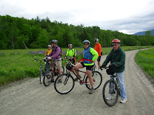
You are cordially invited to join us in an exploration of the Missisquoi Valley Rail Trail in northwestern Vermont. This crushed stone trail runs for 26 miles between St Albans and Richford. It wanders through the farms, forests, fields, and wetlands of Franklin County on steady grades with sweeping bends and postcard perfect landscapes.
We'll be car camping at the Lake Carmi State Park for several nights, which is located a few miles from the mid point of the trail. So each day, for a couple of days, we will ride out and back on about half of the trail.
The State camp ground closes after Labor Day. So we are planning to start this adventure on Sunday August 29th and conclude it by Friday September 3rd. On Tuesday and Wednesday we will actually ride the Missisiquoi Trail. The other days are open for road biking, playing on the lake and just doing the tourist thing.
Please join us!!! The more the merrier!!! Not into camping? There are several inns and B&Bs just off the trail.
If you are interested please let me know which days are available for you between 8/29 and 9/3. I have reserved a lake front lean-to for Sunday to Wednesday nights. More lean-tos should still be available and there are plenty of campsites open.
Here's a short description of the route.
St. Albans to Sheldon Junction
Open, quiet farmland from St. Albans to Green’s Corners. Beautiful wetlands and pines with some residential areas from Green’s Corners to Sheldon Springs. Few road crossings, mostly of gravel roads.
Sheldon Junction to Enosburg Falls
The trail parallels the Missisquoi River offering scenic views of river rapids, quiet pools, working farms, and Jay Peak. Look for fox, deer, and other wildlife. Three crossings of VT 105.
Enosburg Falls to Richford
The trail parallels the Missisquoi River with outstanding views. The landscape offers a nice mix of sunny farmland, shaded forests, and quiet wetlands. Good segment for bird watchers. Multiple crossings of VT 105.
Please thank our local business owners for their generosity in providing restrooms, water, and other services that benefit trail users!
Click below for the trail map.
http://mvrailtrail.com/docs/MVRT-Map-Only-Lo-Res.pdf
Thursday, August 26, 2010
Sunday, August 22, 2010
Wild River Ride
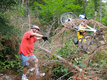
This Tuesday August 24th, we'll ride in the Wild River Valley which is a beautiful place to escape the crowds of August. The route will take us along the lovely Wild River on the tree covered Wild River Road. This is a smooth dirt Forest Service Road which follows the river upstream for 6 to 7 miles to the Wild River Campground and a bit beyond. Then it enters The Wild River Wilderness Area where bikes are not allowed. We may encounter a few cars on this road, but weekday traffic should be light. After checking out the pedestrian suspension bridge past the campground, we'll turn around and head back. Only then will we notice, as we fly back, that the road isn't as flat as it seemed when we we're riding upstream.
When we return to the parking lot there will also be an opportunity to visit the other pedestrian suspension bridge over the river and explore the other side on foot or with bikes. And we can go over to the Hastings Campground to find the Gary Moody special spot http://www.pressherald.com/archive/pittston-man-charged-with-climbing-in-toilet_2009-08-31.html .
Meet in the Forest Service parking lot at the intersection of route 113 and Wild River Road. This is a fee parking lot. If you don't have an annual permit bring a few $1's with you for a one day permit. Be ready to ride out at 9:30am.
Please don't forget bring your cameras!
Directions: Go to Gorham on route 16 north. At the route 2 intersection go right toward Maine. When you get to route 113 go right and drive about 3 miles to the intersection of Wild River Road. Go right again and you'll see the parking lot. For some of you it may be more convenient to pick up route 113 in Fryeburg and take it to our starting point. If anyone wants to carpool meet at the Jackson Old Town Hall parking lot across from the post office at 8:20am.
The forecast for Tuesday is a bit iffy (what's new) so be sure to check this blog at 8:00am if the conditions look sketchy.
Here's a map of the ride.
Sunday, August 15, 2010
Experimental Forest Fun Ride
It's the height of vacation time in Vacation Land. So let's do something really fun. We'll star off at the top of Bear Notch Road and cruise down the dirt roads in the Bartlett Experimental Forest. Then we'll cross over to the east side of Bear Notch Road and do some fun single track and old logging roads on the Reservoir Brook Trail.
Let's meet at 9:30am, in the parking lot off River Road just after it crosses the Saco River in Bartlett. Directions: Take Route 302 to Bartlett, at the blinking light in the center of Bartlett take a right and in about half a mile you'll cross the Saco River and the parking area will be to the left of the bridge. This will be a lovely lunch spot after our mostly downhill ride.
We will need to shuttle people and bikes up to the top entrance of the Experimental Forest (which is almost at the top of Bear Notch) from the parking area. Then we'll start our mostly downhill adventure.
Please bring your cameras! We need more people taking photos!! Thanks!!!
Check back here Tuesday at 8:00am if the weather looks iffy.
Sunday, August 8, 2010
Dam, Dam, Dam and Dam
This favorite ride has a lot of variety, not to mention four or five dams. We'll start off in downtown Gorham by the old train station and ride past the airport and then ride a mile through the backs woods on the emergency access road which is closed to motorized traffic. After this we will be riding on the eastern end of the presidential rail trail to Berlin on the quiet and beautiful eastern bank of the Androscoggin River.
Along with getting great views of the Androscoggin we'll skirt a gravel pit, go over the very high trestle bridge across route 16, bike by the hydroelectric powerhouse and dam on the canal adjacent to the Androscoggin, view the Cascade Flats complex and dam from the seldom seen east side and visit a waterfall, for a lunch stop.
The surface of this pretty flat ride consists of dirt, ballast, gravel and the occasional mud puddle. This 17 mile out and back route is appropriate for all abilities. The ride will start at 9:30 on Railroad Street across from the Gorham Town Common.
Directions: Drive north on route 16 to Gorham. Just before the T intersection with route 2 there will be railroad tracks. Immediately after crossing the tracks turn left onto Railroad Street. Hook a U turn and park on the other side of the road across from the Common.
To view a map of this ride click below.
http://www.mapmyride.com/ride/united-states/nh/-gorham/berlin/275128041664486145
Sunday, August 1, 2010
Tuesday August 3rd - TBD
It's raining Boo, Hiss!!! And the radar shows more showers coming at us this morning. Today's ride is cancelled. We'll try again next week.
The weather forecast is problematic, ambiguous, equivocal, indefinite, indeterminate, iffy and not helpful. We may be able to ride in the morning.
Well it's still too close to call. Check back tomorrow morning around 7:30am.
Here's what I'm thinking. If the weather cooperates we can do a favorite ride of mine which starts in Gorham and is 16 miles long. It goes by the airport onto the emergency access road and then onto the rail trail which follows the east bank of the Androscoggin River to Berlin.
If the forecast is still iffy but it isn't raining in the morning we can explore the trails by the Saco across the street from Attitash and Bear Peak.
If it's raining in the morning just pull the covers over your head and go back to sleep (after you check this blog, of course).
If we ride we'll start at 9:30 on either of the routes.
Subscribe to:
Posts (Atom)