Monday, September 27, 2010
Tuesday, September 28, 2010
All the forecasts indicate that it will be wet and sloppy tomorrow. So sleep in late and enjoy the extra snooze time.
Sunday, September 19, 2010
Tuesday, September 21, 2010
It looks like virtually all the gang is away or otherwise engaged this Tuesday. I was planning on posting the Rob Brook Road Loop. If there is anyone who wants to ride on Tuesday please email me at chumley@earthlink.net and I will post the description of this loop.
Happy Trails, Joan
Happy Trails, Joan
Sunday, September 12, 2010
Explorer's Club
It's damp but doable, let's go!
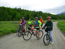
It looks like we'll have a small group Tuesday as several members of the gang won't be able to join us. So let's do something that we couldn't do with a big turn out. How about exploring an area that's close to home? There are some trails near the Scenic Vista in North Conway. And there's only one way to find out where they go.
Please meet at the southern end of the scenic vista parking lot at 9:30am Tuesday.
Check back here Tuesday morning at 8am if the weather looks sketchy.
Sunday, September 5, 2010
Sawyer River Trail and Loop
The Sawyer River Trail is in a seldom visited and very scenic section of the National Forest between the Swift River off the Kanc and the end of the driven portion of Sawyer River Road in Hart’s Location. We’ll get beautiful mountain views especially while we ride the old railroad bed in the wetlands area between Mount Huntington and Green’s Cliff. As a special treat we will have one of the few available views of The Captain (3540ft), which the AMC Mountain Guide calls “a striking little peak, a miniature Half Dome with sheer cliffs overlooking the Sawyer River Valley”.
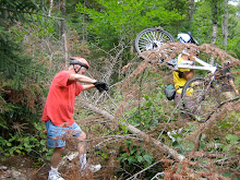
This trail has a number of surfaces including gravel road, double track, dirt path and old rail bed. I imagine that we’ll encounter some mud so plan your foot wear accordingly. This “rail trail” isn’t as smooth as many of the others that we have ridden this year because some of the 100 year old ties are still embedded in the dirt and we’ll encounter lots of tree roots as well. Other than the first half mile the grade is gentle. It’s the surface that is rougher than usual.
After the Sawyer River Trail comes out at the Swift river we'll retrace our route back to the Hancock Notch Trail. Then we'll ride this segment for a half mile and connect to Forest Road 86. Portions of the Hancock Notch Trail have roots and rocks and some of us will walk the bikes in these parts. After we cross a stream and go up a brushy embankment we will have a rollocking 1.5 mile downhill romp back to our vehicles. In all we'll cover about 9 to 10 miles.
Directions: Take Route 302 west and about 4 miles past the Bear Notch Road intersection in the “center” of Bartlett take a left onto Sawyer River Road which is a dirt forest road. Go another four miles to the end and park. This is a National Forest fee parking lot. You can pay there if you don’t have a permit, bring one dollar bills.
Please be ready to ride at 9:30am. See you there.
Subscribe to:
Comments (Atom)