Saturday, July 30, 2011
Kezar Falls Gorge
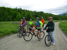
Tuesday AM Update - Let's Go!
Monday Evening Update: Right now it looks like the morning weather will be good for a ride. However if the conditions don't look good tomorrow morning check back around 7:30am for an update.
It’s the height of the tourist season. Has anyone else noticed the epic backups going into and out of North Conway? So we need to get far from the madding crowds. And there’s nowhere more remote and scenic as the Old Waterford /Five Kezars Roads area out of Lovell, Maine. You’ll be surprised at the remoteness of the second half of the ride.
We'll start out at the Lovell Historical Society and take Old Waterford Road to the Kezar Falls Gorge, which Delorme describes as a unique natural area. Then the route will take us to the Five Kezar Ponds where we’ll take a path around one. Next we’ll retrace our tracks back down Old Waterford Road to a dirt road and head out to the Dan Charles Pond area and then after a series of dirt roads we’ll come out on Fern St which will lead us back to Old Waterford Road and the Historical Society.
There are a few hills, primarily at the beginning of the ride so we’ll get our most aerobic exercise during the cooler part of the day. Otherwise the terrain will be relatively easy to cover. The surface will be pavement, pavement reverting to dirt, dirt and packed sandy soil. We should cover about 17 – 19 miles.
Added Bonus: The Historical Society will be open Tuesday so you can nip in there for a look see at the exhibits after the ride.
Please be ready to ride at 9:30am. Park in the lot which is on the left, just across from the historical society building 1.5 miles past the intersection of routes 93 and 5 in Lovell. To get to Lovell take route 5 north out of Fryeburg, Me.
Carpooling: Meet at the Scenic Overlook in North Conway which is conveniently located across the street from Trails End Ice Cream Shop. Meet Time 8:40am
Weather Note: The weather forecast while I’m writing this is for a sunny day with a high Temp of 79. I’m going to post this ride Saturday as I’ll be computerless for the next couple of days. If the forecast does change significantly please check back on Monday evening for an update.
Sunday, July 24, 2011
Bretton Woods Triangle
Tuesday Morning Update: The webcams in Bretton Woods show rays of sun coming through the clouds and the weather radar looks clear. So let's ride!
It looks like we may be able to get a ride in tomorrow morning. So let's try something we haven't done for almost two years - the trails in the National Forest in the triangle created by Route 302, Mt Clinton Road and the Base Road (for the Cog Railway). The word is that these trails have improved in the last couple of years. Generally speaking there will be a gradual, but quite doable, climb during the first half of the ride and a subsequent down hill ride in the second half. We'll cover about 10 - 12 miles of these woodsy and scenic trails.
Meet at 9am at the Eisenhower Memorial Wayside Park which is on the right side of Route 302 between the AMC Center and the entrance to The Mount Washington Hotel.
Carpooling: 8:30 in the Attitash parking lot.
Weather Note: Check this blog tomorrow morning around 7:45 to confirm that the ride is still on.
Sunday, July 17, 2011
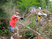
Sawyer River Trail and Loop 7/19/11
The Sawyer River Trail is in a seldom visited and very scenic section of the National Forest between the Swift River off the Kanc and the end of the driven portion of Sawyer River Road in Hart’s Location. We’ll get beautiful mountain views especially while we ride the old railroad bed in the wetlands area between Mount Huntington and Green’s Cliff. As a special treat we will have one of the few available views of The Captain (3540ft), which the AMC Mountain Guide calls “a striking little peak, a miniature Half Dome with sheer cliffs overlooking the Sawyer River Valley”.
This trail has a number of surfaces including gravel road, double track, dirt path and old rail bed. I imagine that we’ll encounter some mud so plan your foot wear accordingly. This “rail trail” isn’t as smooth as many of the others that we have ridden this year because some of the 100 year old ties are still embedded in the dirt and we’ll encounter lots of tree roots as well. Other than the first half mile the grade is gentle. It’s the surface that is rougher than usual.
After the Sawyer River Trail comes out at the Swift river we'll retrace our route back to the Hancock Notch Trail. Then we'll ride this segment for a half mile and connect to Forest Road 86. Portions of the Hancock Notch Trail have roots and rocks and some of us will walk the bikes in these parts. After we cross a stream (50% chance of getting wet feet), we’ll go up a brushy embankment and have a rollicking 1.5 mile downhill romp back to our vehicles. In all we'll cover about 9 to 10 miles.
Directions: Take Route 302 west and about 4 miles past the Bear Notch Road intersection in the “center” of Bartlett take a left onto Sawyer River Road which is a dirt forest road. Go another four miles to the end and park.
Please be ready to ride at 9:00am. See you there.
Monday, July 11, 2011
Judy and Joe's Freedom Ride
Judy and Joe have found a great new adventure for us in the Freedom Town Forest. Here's the ride in their own words.
TROUT POND, FREEDOM, NH
DIRECTIONS:
Drive south on route 16 to Conway and take route 153, passing Crystal Lake Inn. Continue past Purity Springs Resort and take a Right on Bennett Road. Follow this tending right and take the first RIGHT after the BLUE MOON STORE. There will be a sign for Trout Pond and Mary's Mountain. Drive down winding paved road to blue signs. Turn LEFT for Trout Pond, and we'll meet at the parking area and kiosk at 9:15 a.m.
At 9 a.m. we'll be at the first King Pine parking lot on the left to meet with anyone who wants to convoy to the Trout Pond parking area.
Carpooling: Meet at the Scenic Vista in North Conway at 8:20am
THE RIDE
From the kiosk parking lot we'll head out on Jackman Ridge Trail riding through "patch cuts" conducted in 2006. It's the removal of larger trees to encourage aspen/birch sapling growth that provides preferred habitat for a variety of wildlife species. Turning left, we'll take a quick side trip to the interesting, abandoned Freedom Airstrip to see a beaver pond. Returning to Jackman Ridge, We'll ride north to the entrances for Trout pond. We'll ride to the second entrance and enter the Outlet to Trout where we'll have lunch. From there we'll go downhill most of the way to Mary's Mountain kiosk. We'll turn right and take the mostly paved Shawtown Road back to the cars.
Total miles: 7 to 10
Time: 2+ hours
Approximate elevation gain over 3 miles: 300’
The weather forecast looks good for tomorrow morning. However if the conditions change check back here by 7:45am.
Sunday, July 3, 2011
Dam, Dam, Dam, Dam and Dam
Tuesday July 5th we'll ride this favorite route, which runs from the Gorham train depot to the Berlin eastside depot. It has a lot of variety, not to mention about five dams. We'll start off in downtown Gorham by the old train station and ride past the airport and then ride a mile through the backs woods on the emergency access road which is closed to motorized traffic. After this we will be riding on the eastern end of the presidential rail trail to Berlin on the quiet and beautiful eastern bank of the Androscoggin River.
Along with getting great views of the Androscoggin we'll skirt a gravel pit, go over the very high trestle bridge across route 16, bike by the hydroelectric powerhouse and dam on the canal adjacent to the Androscoggin, view the Cascade Flats complex and dam from the seldom seen east side and visit a waterfall, for a lunch stop.
The surface of this pretty flat ride consists of dirt, ballast, gravel and the occasional mud puddle. This 17 mile out and back route is appropriate for all abilities. The ride will start at 9:00 on Railroad Street across from the Gorham Town Common. Please note the earlier start time, it's forecasted to be a hot day.
Carpooling: Meet at the Old Jackson Town Hall, parking lot (across from the post office) at 8:20.
Directions: Drive north on route 16 to Gorham. Just before the T intersection with route 2 there will be railroad tracks. Immediately after crossing the tracks turn left onto Railroad Street. Hook a U turn and park on the other side of the road across from the Common.
To view a map of this ride click below.
http://www.mapmyride.com/routes/view/20611220
Subscribe to:
Posts (Atom)