The colors have really popped in the last few days. So now is the time to visit the gorgeous Pondicherry area.
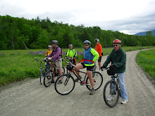
We’ll start at the western terminus of The Presidential Range Rail Trail and pedal through almost four miles of The Pondicherry National Wildlife Refuge where the views are absolutely magnificent. Then we’ll head for more open vistas on three miles of paved country road and another three plus miles on the dirt Valley Road. When we reach Jefferson Notch Road we will return to Pondicherry on The Rail Trail. In all we’ll cover about 18 miles with breath taking mountain views and the panoply of wild flower filled fields.
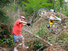
The rail trail has a pretty firm surface and is a combination of dirt, gravel, stone, cinder and ballast. This is a relatively flat route with no major hills. It’s just a wonderful cruise through a beautiful area.
Directions: Take route 302 through Bretton Woods and at the traffic light go right on route 3 for 1.9 miles. Then take another right on route 115. In 4.4 miles Hazen Road will be on your left, take it. In another 1.4 miles you will see a sign on the right that says Trail Parking. Go right into the small parking lot. We may have to do some creative parking to fit us all in here.
Carpooling is a must due to the small parking lot at Pondicherry. Meet at 9:00am at the far west end of the Attitash
Click here for a map of this ride.
http://www.mapmyride.com/routes/view/11313897
We’ll start at the western terminus of The Presidential Range Rail Trail and pedal through almost four miles of The Pondicherry National Wildlife Refuge where the views are absolutely magnificent. Then we’ll head for more open vistas on three miles of paved country road and another three plus miles on the dirt Valley Road. When we reach Jefferson Notch Road we will return to Pondicherry on The Rail Trail. In all we’ll cover about 18 miles with breath taking mountain views and the panoply of wild flower filled fields.
The rail trail has a pretty firm surface and is a combination of dirt, gravel, stone, cinder and ballast. This is a relatively flat route with no major hills. It’s just a wonderful cruise through a beautiful area.
Directions: Take route 302 through Bretton Woods and at the traffic light go right on route 3 for 1.9 miles. Then take another right on route 115. In 4.4 miles Hazen Road will be on your left, take it. In another 1.4 miles you will see a sign on the right that says Trail Parking. Go right into the small parking lot. We may have to do some creative parking to fit us all in here.
Carpooling is a must due to the small parking lot at Pondicherry. Meet at 9:00am at the far west end of the Attitash
Click here for a map of this ride.
http://www.mapmyride.com/routes/view/11313897